The Project Gutenberg eBook of The exploration of Tibesti, Erdi, Borkou, and Ennedi in 1912-1917
This ebook is for the use of anyone anywhere in the United States and
most other parts of the world at no cost and with almost no restrictions
whatsoever. You may copy it, give it away or re-use it under the terms
of the Project Gutenberg License included with this ebook or online
at www.gutenberg.org. If you are not located in the United States,
you will have to check the laws of the country where you are located
before using this eBook.
Title: The exploration of Tibesti, Erdi, Borkou, and Ennedi in 1912-1917
a mission entrusted to the author by the French Institute
Author: Jean Tilho
Release date: October 17, 2025 [eBook #77071]
Language: English
Original publication: London: The Royal Geographical Society, 1920
Credits: Galo Flordelis (This file was produced from images generously made available by the HathiTrust Digital Library)
*** START OF THE PROJECT GUTENBERG EBOOK THE EXPLORATION OF TIBESTI, ERDI, BORKOU, AND ENNEDI IN 1912-1917 ***
This article has been extracted and prepared from
The Geographical Journal, v. 56, 1920.
[No. 2
81]
THE EXPLORATION OF TIBESTI, ERDI, BORKOU, AND ENNEDI IN
1912-1917: A Mission entrusted to the Author by the French
Institute
Lieut.-Colonel Jean Tilho, Gold Medallist of the
R.G.S. 1919
Read at the Meeting of the Society, 19
January 1920. Map following p. 160.
[Note: The names in the text are
spelled in accordance with the manuscript of Colonel Tilho, a few
of the principal names—as Chad—in their English form, but the
greater number in the French transliteration of Arabic. On the
accompanying map the names are transliterated according to the
G.S.G.S. rules for transposing from the French to the British
system. The retention of the French spelling in the text has the
double advantage of familiarizing the student with the two systems,
and of preserving in some degree the character of the lecture,
which was delivered in French.—Ed.G.J.]
1. Object of the Mission.
BEFORE I begin my lecture, allow me to express once
more, in your presence, my heartfelt gratitude to the Council of
the Royal Geographical Society for the high recompense accorded me
on the occasion of my last journey in Central Africa.
It is of this journey, its chief incidents, and most important
results, that I am about to have the honour of giving some account.
Let me first of all explain to you, in a few words, what, from a
geographical point of view, was the object of my expedition.
Explorations in Central Africa, made during the second half of
the nineteenth century and in the beginning of the twentieth, had
left unsolved a very interesting problem: it had been noticed that
the level of vast stretches of desert, several hundred miles
north-east of Lake Chad, were considerably lower than that of the
lake—the difference amounting in some places to 260 feet; besides
this, a wide continuous trench, offering the appearance of an old
valley—the Bahr El Ghazal—led from the lake to this low-lying
ground, and seemed to stretch far away to the north-east, between
the mountain groups of Tibesti and Ennedi. On proceeding towards
the north-east, an increasing analogy is to be noticed
between[82] the
malacological fauna of the Chad basin and that of the Nile. Besides
which there had been found recently, in the waters of the Chad, a
shrimp till then only found in the Nile basin—the Palæmon
Niloticus, Roux. In short, all these signs appeared to confirm
the supposition that the basin of the Chad was not a closed basin,
but belonged to that of the Nile, and was a former affluent of the
old river on whose banks had sprung up and flourished one of the
most brilliant and ancient civilizations of the world.
This was the hypothesis that the French Institute wished to have
investigated, and in the early part of 1912 I had the honour to be
chosen to undertake the necessary researches. May I tell you how
the mission thus entrusted to me fulfilled my dearest wish? From my
early youth I had felt myself irresistibly drawn towards Africa,
and I was filled with a desire to take a modest share in the
discoveries of great explorers, whose intrepid expeditions had
revealed to the civilized world some part of the mysterious and
immense dark continent.
You doubtless remember how vague, some thirty years ago, was our
knowledge of that part of the world. At that time—which now seems
so far away even for those then living—I had for chaplain at the
grammar-school a holy man who was an ardent patriot; in his Sunday
sermons he used to talk to us a little of our duty to God, and
still more of our duty to our humiliated country, which was waiting
and meditating, as it laboured, on the possible reparation of the
iniquities of 1871. His voice, sad at first while he spoke of our
disasters and the sufferings of our lost provinces, soon grew eager
and thrilled as he showed us the new way to be taken by children,
as we then were, to raise the prestige of our flag: he would speak
to us of that mysterious Africa, half revealed by Livingstone,
Stanley, and Savorgnan de Brazza; and I fancy, after these thirty
years, I still hear the sound of the name of Savorgnan de Brazza
re-echoing through our humble chapel and thrilling like a
bugle-call. Then, of an evening in the class-room, I would ponder
over the map of Africa, where amid great blank spaces appeared in
the centre of the continent a few geographical features, one of
which, coloured in blue, Lake Chad, possessed a singular
fascination for me.
Some years later, on leaving Saint-Cyr, I began to look forward
to the realizing of my dream: after a first campaign in Madagascar,
I was sent out to serve on the banks of the Niger in 1899; and
since that date each successive campaign in Africa allowed me to
push a little further eastwards, and so get to work on a fresh item
of the programme I had set myself to carry out: to establish an
accurate geographical liaison between the basins of the Niger, the
Chad, and the Nile, and unite by a great transversal line the
extreme ends of the routes followed by Nachtigal to Tibesti,
Borkou, Wadai and Dar Four.
In 1912 I was ordered to take command of the province of Kanem
for the purpose of preparing a projected expedition against
Borkou,[83] where the
Senoussists had established their chief centre of agitation and
anti-French propaganda, and whence they periodically sent out
plundering expeditions, which spread ruin and desolation among the
peaceful tribes placed under our protection. About the same time,
the Académie des Inscriptions et Belles-Lettres entrusted me with
the mission I mentioned above, concerning the supposed connection
between the basins of the Chad and of the Nile. Of this latter
expedition, which lasted five years—1912-1917—I now propose to give
you a résumé.
2. From Congo to Borkou.
From Congo to Lake Chad.—I do not think there would be
any real interest in a detailed account of my journey to Kanem; I
followed a route pretty well known, the Congo-Ubangi-Shari route.
We left the steamer at Matadi, at the foot of the cataracts, and
took the Belgian railway which leads to Kinshassa on Stanley Pool,
at the head of the cataracts; from there, after crossing the Congo
to land at Brazzaville, we proceeded on a river-steamer, first up
the Congo itself, and then up its tributary the Ubangi, as far as
Bangui. Farther up, lighter steamers enabled us to surmount the
rapids and reach Fort De Possel, a little post built on the right
bank at the point where the Ubangi changes its course. From Fort De
Possel we went by land to Fort Crampel, covering nearly 160 miles
of the zone which divides the waters between the basins of the
Congo and the Chad. A fine road for motor-cars was being completed
when I passed, but the only means of transport was carriers on
foot. At Fort Crampel we embarked in small boats and descended the
Gribingui till it falls into the Bahr-Sara, taking farther down the
name of Shari; from thence we proceeded on a river-steamer up the
Shari till we reached the Chad, and crossed over to the post of
Bol, on the northern shore of the lake; and finally, in four more
stages, we reached by land the town of Mao, the military and
political centre of Kanem.
This journey, which takes about twelve or fourteen weeks,
according to the season, is very interesting for travellers, and
especially for sportsmen, who find opportunity for exercising their
skill on game of all sizes, from the elephant and the lion to the
modest guinea-fowl. I may mention that when I passed by the banks
of the Shari, the remembrance of the exciting hunts of the
celebrated aviator Latham, killed by a buffalo, was still fresh in
every one’s mind; but does any one remember Latham now? We should
notice that this line is still far from comfortable, and that the
ever-present danger of catching the sleeping sickness through the
myriads of glossina-flies that may sting the traveller, spoils all
the pleasure one would feel in beholding the splendid landscapes of
tropical rivers flowing beneath the shady arches of the quiet
forests.
A Year in Kanem (1912-1913).—I will pass briefly over
the twelve months’ period of my command in Kanem and the
neighbouring districts. My daily task—military, political,
administrative, and judicial as well—[84]was such that the days seemed too short for
the business to be done. It must be said indeed that the Kanembus,
the Budumas, the Toubous, and the Arabs of this region may be
reckoned among the most quarrelsome and litigious people one can
imagine.
But the great matter was to be informed in time of the
Senoussist raids, and when that could not be done, to discover and
cut off their retreat towards their distant haunts; but we had to
do with old stagers of the Sahara, who knew admirably well to wait
for the right moment, and beat a rapid retreat with their booty
once the thing was done.
Another important matter was the material preparation for the
expedition planned against Borkou and Tibesti, where the
Senoussists assembled their bands of brigands, and where they
concealed their booty: camels, horses, cattle, and, above all,
women and children, carried off into slavery.
The secrecy of this expedition was ensured through the simple
fact that our enemies’ spies had so often announced the formation
and imminent setting out of a punitive column, as to render the
Borkou gentlemen quite incredulous of its possibility; they were
startled, however, when in July I led a reconnoitring party to the
extreme limits of our frontier, but as I retraced my steps without
going beyond this line, they were confirmed in their opinion that
we should not dare to attack their fortress of Ain Galakka, and
they recommenced more boldly than ever their incursions and
plunderings among our villages and our tribes. For this reason,
when, in the early November of 1912, Colonel Largeau came and
assumed the command of an expeditionary column, our departure for
the north-east was not considered by the Senoussists of Borkou as
more threatening to them than any reconnoitring party of the
preceding months had proved to be.
3. In Borkou.
The Conquest of Borkou.—Our expedition consisted of 400
black soldiers, with two mountain-guns; about 200 Arab and Toubou
volunteers, forming a “goum” or party of scouts, accompanied the
column. We carried with us provisions for forty days, and the total
number of our camels was about 2000. By a rather extraordinary
piece of good luck, our forward march was not disturbed by the
enemy. The season was favourable, the days not being over-hot, and
the nights fairly cool; the usual temperature at sunrise was about
60° Fahr., but a very strong wind, blowing from the north-east and
raising blinding clouds of sand, made it seem a great deal colder.
Our march was skilfully concealed as far as Kourouadi, a point from
which we could threaten the fortress of Ain Galakka as easily as
that of Faya. There, after allowing the troops a day for rest and
final preparation, it was decided to strike a decisive blow at Ain
Galakka, the principal centre of the Senoussist forces.
Our column, leaving its convoy a dozen kilometres in the rear,
under a guard of fifty men, appeared before Ain Galakka on the
morning of[85] 27
November 1913; the enemy were completely surprised. The attack
began by a bombardment of no more than about a hundred shells,
which did great damage inside the zawia, and made in the
outer wall many a breach for the infantry to pass through. The
assault was opened at ten o’clock; the defenders, though not
numerous, offered a vigorous resistance, preferring to die rather
than surrender; by mid-day the entire fortress was in our hands. We
had about forty casualties, of which a third were killed.
THE COLUMN HALTED AT THE WELLS OF KOUROUADI,
BORKOU
THE FORT OF BERRIER-FONTAINE, OASIS OF FAYA
ROCKY COUNTRY BETWEEN THE OASES OF YARDA AND BÉDO,
BORKOU
DANCE OF THE NAKAZZAS, OASIS OF FAYA, BORKOU
Leaving our wounded in Ain Galakka with a small garrison, we
marched on the zawia of Faya, which we entered without
striking a blow on December 1. Thence proceeding still farther into
the desert, we reached in a week’s time Gouro, a point 200
kilometres north, the religious and political centre of the
Senoussists in Central Africa, which was seized after a short
struggle. Then, continuing its successful march towards the east,
the column took possession unopposed of the oasis of Ounianga, 60
miles from Gouro, and leaving a small garrison there we returned to
Faya, the best place to be chosen for the military and political
centre of the newly conquered territory.
Importance of the Conquest of Borkou.—This laborious
campaign had the very important result of depriving the Senoussists
of the valuable tête de pont on the south side of the
Sahara which Borkou constituted for them, enabling them to
distribute over Central Africa arms, ammunition, and propagandists
of the holy war.
The great value of our conquest appeared plainly a few months
later, when the German Emperor let loose on the world the most
awful war that ever convulsed the Universe: a Germano-Turkish
mission, headed by Nuri Bey, a brother of Enver Pasha, the Turkish
Minister of War, landed in Cyrenaica for the purpose of organizing,
with the help of the Senoussists, an outbreak in Central Africa
against the protectorates of France and Great Britain. This would
have been an easy matter if our enemies had been able to establish
their headquarters in Borkou, for they would then have been only a
few hundred miles from German Bornou on one side, and on another
from Dar Four and Dar Sula, which showed a certain hostility
towards us. There is no doubt that, in this case, the Anglo-French
campaign in the Cameroons would have been conducted in very
different circumstances; when we take into consideration the large
stock of arms and ammunition prepared by the Germans in their
colony, and the care they had taken to fortify the mountain of
Mora, we may suppose that the German staff had hoped to establish
by main force a continental junction between the Cameroons and
Turkey, through Kanem, Borkou, and Libya, in case of the
communication by sea being cut off. And I do not think I shall
betray any State secret by informing you that the Chad territory,
with its modest resources in men and ammunition, would have been
very difficult to defend with any chance of success against such an
attack. I may also add that, had the Turco-Germans been able
to[86] accomplish their
design, the result would have been exceedingly perilous for
Franco-British rule throughout the whole of Dark Africa.
By uniting, under my command, our frontier territories of the
Libyan desert, the French Government’s aim was to constitute a
force able to resist any attempts that might be made to retake from
us the excellent base of operations that Borkou afforded.
Four Years in Borkou (1913-1917).—I do not think it
would be of any great interest to lengthen this geographical
lecture by explaining to you the difficulties of every kind that I
was obliged to overcome during about four consecutive years, in
order to fulfil the military task allotted to me. As Borkou
produces little else but dates, and Ennedi scarcely anything at
all, I was compelled to procure from Kanem and from Wadaï the corn,
meat, and other food-stuffs necessary for the maintenance of my
civil and military subordinates. Now, the organizing of the
commissariat transport became more and more difficult every six
months; the want of pasture along the roads we had to take, the
incessant raids of the nomads and the counter-raids of my troops,
caused irreparable losses among our camels. From the end of 1913 to
the first months of 1917, the activity of the rebels was so great,
owing to the instigation of the Turco-Senoussists, that my troops
could get no rest.
A Bird’s-eye View of the Country.—When on leaving the
shores of Lake Chad we proceeded towards the north-east, we first
entered into a sandy region, with parallel valleys running between
grassy downs that rose to a height of not more than 300 feet: this
was Kanem, the country of corn and cattle, where subterranean water
abounds and where it is easy to live.
After marching for about 100 miles, we left this fertile country
and dropped quite suddenly into the desert itself, with its dull,
empty, vague horizons, so monotonous that the slightest details
interested us, such as a line of stones on the sand, the sight of a
crescent of sand-dunes, or a poor, solitary, half-dead shrub; also
our passing through a meagre pasturage of dusty had was
quite an event, or the discovery in the distance of a few green
bushes of siwak, till we reached the wells, where we were
to rest all day long, to lead the camels to drink, and renew our
own provision of water, which was often brackish and evil-smelling.
This was the deceptive desert of the Lowlands of the Chad, the
region I mentioned above as being lower in level than Lake Chad
itself.
After a further march of about 250 miles we entered the country
of rocks; at first scarcely visible above the sands, they soon rose
in sharp peaks that looked like mediæval ruins, and then shot up
into long steep cliffs bordering rugged plateaux, that formed
ledges one above the other to the foot of the mountains: this was
the region of Borkou, Tibesti, and Ennedi, the very heart of the
desert, situated at almost the same distance from the shores of
Lake Chad, the Nile, and the Mediterranean. This rocky belt forms,
from the Tripolitain to Dar Four, a long broken wall,[87] encircling on the north-east the
basin of the Chad, which it divides from the dismal and unexplored
waste of the Lybian Desert. Tibesti and Ennedi form the highest and
almost inaccessible parts of this region, while another part,
Borkou, consists of a wide depression between the basins of the
Chad and of the Nile.
4. The Oasis of Borkou.
Faya.—The zawia of Faya had been chosen as the
military and administrative centre of French Borkou, in preference
to those of the Senoussists (Ain Galakka and Gouro), because it
offers the least unfavourable lines of communication with the
garrisons of Gouro, Fada, and Ounianga, and the best position for
joining Borkou by wireless telegraphy to the nearest post of the
Chad territory, 350 miles to the south.
The huts of the Senoussist zawia sheltered us from the
sun and the sand-storms, but they were in such a state of ruin and
decay that we were obliged to begin at once and make
bricks—unbaked, of course. Unluckily, for constructing our
buildings we were obliged to depend on the work of the few black
soldiers who were not employed in exterior operations; so that many
months elapsed before we could build a sufficient number of
habitable houses, and complete the detached works of our defensive
arrangements, including three rows of rope network, supposed to be
barbed, by means of the addition of long thorns from the
date-trees.
The landscape from the summit of the square donjon which
overtopped the fort, though wanting in charm and beauty, was not
without a style of its own; the post was built in the middle of a
broad valley, closed in on the east, but opening spaciously towards
the west; its rugged, steep, rocky sides plunging into shifting
sands and wind-swept dunes, each dune curved into the form of a
crescent.
At the foot of the fort the axis of the valley was delineated by
fine rows of date-bearing palms, about 500 yards wide by 20,000
long, broken at intervals by heaps of moving dunes. On either side
of the palm-grove there stretched green meadows, which looked as
though they would afford fine pasturage for cattle, but which in
reality were covered with sharp, hard grasses and herbs of no
nutritive value: the most characteristic and the least bad was
akul, a regular little bush of sharp thorns, which the
camels would eat, but not without making a funny grimace at every
mouthful.
All along the valley there lies a sheet of subterranean water,
which rises in some places so near to the surface that the gazelles
and jackals easily slake their thirst by scraping away with their
feet a few inches of the soil; here and there, indeed, a little
stream of water flows out of the sand, and runs a few yards towards
a neighbouring depression, and little pools are formed in natural
or artificial hollows made in the soil.
These jackals and gazelles are the only wild animals found in
Borkou; the latter are quite unapproachable by hunters, while the
former remain[88] hidden
in the daytime, but come in bands at night, yelping round the
villages, and penetrate boldly into inhabited enclosures to seek
their prey. So cunning are they that they avoid the most ingenious
traps the natives can set. The lion, the panther, the hyena, and
the wild boar never pass beyond the desert boundaries of Kanem and
Wadaï; even the antelope and the ostrich, though bearing thirst so
well, cannot venture so far into the Sahara.
The winged domestic tribe is seen among the villages in the
shape of rare squads of lean fowls; and flights of turtledoves and
pigeons roost in the palm trees. A graceful species of sparrow,
with black plumage and white tails, fly in and out of the rocks,
and even come into our clayhouses; they sing like nightingales when
building their nests, and chirp like sparrows while they watch
their young beginning to fly. All round the inhabited houses the
black crows may be heard croaking: they are extremely audacious,
whether attempting to snatch pieces of meat roasting before a
kitchen fire, or settling on the back of a wounded camel and
tearing off with their beaks morsels of bleeding flesh.
Snakes are fairly common, the largest being hardly more than a
yard in length and one or two inches thick; the most dangerous is
the short bulky viper that lies hidden in clumps of grass, and
whose bite is fatal even to camels. Scorpions abound, generally of
a greenish hue, sometimes black; their sting is very painful, and
may be eventually mortal to women and children.
Amidst the rocks one may find a curious eatable lizard, the
“dundou”; it is inoffensive, but when it does bite, it bites so
fiercely that the only way of making it let go is to pinch its tail
sharply, either with pincers or with one’s teeth.
There are very few domestic animals save the ass and the goat;
but small herds of oxen manage to cross the desert from November to
February, when cool days, pools remaining from the rainy season,
and the scanty pasturages of grasses produced here and there by the
few summer showers allow them to pursue their march by short
stages.
Where the animal kingdom exhibits its greatest vitality,
however, is in the insect world: the common fly, dirty and
worrying, rules despotically by day, together with gad-flies and
big stinging flies of a pretty greenish hue. At nightfall, the very
time when one might enjoy a little rest on the terrace of the
houses, moths, coleopters, locusts, dragonflies, and bugs become
very lively, and whirl madly round the table where a light is
shining, so that it is far preferable to dine lighted only by the
moon and the stars. When there is no wind at night there are swarms
of mosquitoes, and also of a kind of little sand-fly that pass
between the meshes of the best mosquito-nets.
SANDSTONE ROCKS NEAR ORORI, BORKOU
ROCK DRAWINGS, OASIS OF YARDA, BORKOU
SANDSTONE ROCKS ATTACKED BY MOVING DUNES, OASIS OF
YARDA, BORKOU
Cultivation.—The soil indeed is not very fertile, which
is the reverse of the account given of most oases in the north of
the Sahara. It is especially favourable to the cultivation of the
date-bearing palm, which[89] loves to have its foot in the water and its
summit in the burning sun, but does not stand rain well. The first
dates ripen in the month of May, while the latest are gathered in
September; they vary in size, and are dark or light in colour
according to their variety, but nearly all are of a very good
quality, as sweet and fleshy as one could wish. The greater part of
the crop is put to dry, while the most luscious are gathered into
heaps and pressed into goatskins, to be carried to Wadai and Kanem
and other places farther off.
After the date-gathering the natives prepare their gardens for
the sowing of corn, which takes place in November and December. The
ground is arranged in small squares, ingeniously adapted for
irrigation; but the produce is meagre owing to the want of manure;
this is remedied, to a certain extent, by an addition of virgin
soil, containing more or less soda, which is fetched from some
distance on donkey-back. The gardens are intersected with long
parallel hedges, which shelter the ears from the withering violence
of the north-east wind. The harvest is gathered in towards the end
of March, and a short time later the ground is prepared for the
sowing of millet, which yields a still smaller crop than the corn.
When we add that in some gardens there grow a few onions and
tomatoes, as well as a kind of spinach, scarcely appreciated
anywhere but in Borkou, we shall have enumerated nearly all the
available food-stuffs of the oases.
I must not forget to mention that the Senoussists had succeeded
in importing to Gouro and Faya some fig-trees and a few vines; and
on our side we managed to acclimatize the sweet potato, a precious
resource which came from Kanem. We were less fortunate in our
repeated attempts to acclimatize French vegetables, which succeed
so well in the neighbourhood of Lake Chad during the cool season;
the poverty of the soil, the want of manure, the extreme dryness of
the north-east wind, the voracity of the grasshoppers and other
destructive insects, were no doubt the causes of our lamentable
failure as agriculturists.
Winds and Rain.—In the heart of the Sahara, where rain
is so rare a meteorological phenomenon, the wind is the high
arbiter of each day’s weather. The weather is fine when the wind is
light, and bad when it is strong; in the latter case nothing is to
be seen but whirling columns of sand, raised by the north-east
wind, blowing in stormy gusts and covering the whole landscape with
a thick dry mist of brownish dust that penetrates everywhere and is
very painful to the eyes, so that one does well on such occasions
to wear motor-goggles to avoid ophthalmia. These north-east winds
blow more or less violently for a great part of the year, sometimes
for a few hours only each morning, sometimes for whole days and
nights. I may say that we were able to note a fair correlation
between the oscillations of the curves of the registering barometer
and thermometer and the force and duration of these winds; they
usually coincide with low temperatures and high atmospheric
pressure, while the light winds or the dead calm accompany low
pressure and high temperatures. Taking as a[90] basis the information furnished by the
natives, borne out by our four years of regular observations, it
may be said that, as a general rule, the north-east wind reigns
supreme over Borkou and the neighbouring districts from October to
May or June (that is to say, from about the autumnal equinox to the
summer solstice); whereas in July, August, and September still
weather prevails, alternating with gentle west-south-westerly
winds.
It is these latter winds that bring with them from the Atlantic
what little moisture nature measures out each year so
parsimoniously to these dried-up lands. Then the sky clouds over
almost every afternoon, but one’s hope of refreshing showers is
vain; the heat thrown up from the scorched ground, and the rapidly
rising temperature through which the raindrops fall towards the
earth (a rise of about 3° Fahr. per 1000 feet), are enough to bring
about their more or less complete evaporation before they reach the
ground, and one sees long frayed streaks of grey cloud trailing
almost along the ground, like unravelled skeins of wool, from which
a few rare drops fall on the thirsty earth. When we took possession
of Borkou the inhabitants assured us with one voice that it had not
rained in their country for eleven years, thus putting back the
date of the last rain to the year 1902; by a curious chance our
entry into Faya (on 1 December 1913) was greeted by a little shower
of utterly unlooked-for rain. The inhabitants saw in this downfall
(unusual not only for that region, but for that season of the year)
a happy omen for the rainy season of 1914, an omen which was
realized, for in the month of August 1914 we had the satisfaction
of registering about 90 mm. of rain at Faya. In 1915 the rainfall
was hardly worth mentioning, and in 1916 about 35 mm.
Though Borkou is more than 300 miles south of the Tropic of
Cancer, and very low-lying (650 feet above sea-level), the heat is
really excessive only for six or seven months of the year, from
mid-March to mid-October. During our observations, extending over
three years, the maxima registered in the hot season never exceeded
117° Fahr., but temperatures of 110° to 115° were frequent. During
the cool season, from December to February, the minima sometimes
fall below 50° Fahr. without ever getting down to freezing-point.
The dryness of the air is very noticeable from November to June,
when a difference of more than two to one may regularly be observed
between the simultaneous indications of the dry and wet
thermometers: for instance, when the former stands at 44° C. the
second often reads less than 20°. On the other hand, in August and
September, under the influence of the winds blowing from the
Atlantic Ocean, the air becomes very damp and the heat grows
stifling.
In spite of its excessive heat, the climate of Borkou is
comparatively healthy; very relaxing during the hot and damp
season, it is extremely pleasant in the months corresponding to our
autumn and winter. During my stay, lasting from 1913 to 1917, none
of my European fellow-workers had any serious illness, and my black
troops, though kept hard at work in[91] the shape of arduous reconnoitring and escort
duty, and with barely enough to eat, showed a percentage of
sickness and deaths below the average of the other garrisons
throughout the Chad Territory.
Population and Commerce.—The population of Borkou
consists of nomads, the Tedas and the Nakazzas—the great nobles of
the desert—and of a sedentary tribe, the Dozzas, who are only half
noble, for want of the few camels whose possession would enable
them to take a share in the profitable plundering raids in the
desert. There is also a third category of inhabitants, the Kamajas,
half serfs, half slaves, whose duty it is to attend to the gardens
and the plantations of palms, and who are profoundly despised by
the other two categories. The total population of Borkou would not
appear to exceed some ten thousand souls, distributed among a score
of more or less flourishing palm plantations.
The commercial activity of the oases of Borkou is far from
negligible; they export towards the south salt, soda, and dates,
and receive in exchange cereals, butter, cattle, and smoke-dried
meat. Caravans of two hundred camels may often be seen coming to
load up with salt at the Arouelli salt-pits near Ounianga; and Arab
caravans pass by on the way from Cyrenaica, by Koufra and Sarra
wells, importing to Wadai stuffs, sugar, coffee, tea, mercery, and
(in time past) arms and ammunition; and exporting principally
millet, butter, smoked meat, hides raw or tanned, ostrich feathers,
elephants’ tusks, and so forth. The slave-trade, formerly carried
on through Borkou between Wadai and Cyrenaica on a great scale, has
almost entirely ceased since we took possession of the country.
5. Exploration of the Western Borders of the Libyan Desert:
Ounianga-Erdi
After drawing up the map of the western part of Borkou,
subsequent to my reconnaissance in March and April of the various
oases that succeed one another between Faya and Ain Galakka on the
south and Gouro on the north, I devoted the last quarter of 1914 to
an exploration of the unknown regions situated further east. Over
and above their geographical interest, the said regions were of
great military importance. My object was, in fact, to ascertain
whether a counter-attack by the Senoussists, starting from Koufra
and crossing the Libyan desert, could easily hope to escape the
vigilance of our camel-corps patrols and fall on the remoter
borders of Borkou and Ennedi.
From Faya to Ounianga.—With this intention I left the
oasis of Faya on 1 October 1914, at the head of a small escort,
taking with me only some thirty lean camels tired and mangy, only
capable of short stages and of carrying light loads. The result was
that I spent nine days in covering the 117 miles between Faya and
Ounianga, a journey that offers no difficulties and is usually
completed in five or six stages. The points at which water may be
found are frequent—at least one every 20 miles—and permanent; but
grazing-grounds were almost non-existent at that time in
consequence of the eleven years’ drought the country had
just[92] suffered from.
The rain that had fallen in August had, it is true, made a few
green blades spring here and there, and they were eagerly snapped
up by our camels as they passed; but they were still so scattered
among the broken rocks that they rather emphasized than diminished
the desolate barrenness of these dreary solitudes. From place to
place, round a water-hole, one found a few wretched acacias, bushes
of rtem or tufts of akrech. By chance one would
come across what had once been a field of dried-up hâd
whose thorny branches were grey with dust; but in a general way the
landscape was disappointingly bare, and I wondered anxiously how
long my camels would hold out on this starvation diet.
The route passed alternately through hamadas of sandstone, the
blackened rocks of which emerged from irregular dunes, and through
sandy plains into which one sank, raising thick clouds of dust
finer than ashes. We did not meet a living soul on the way, except
a detachment going back to Faya, and a little caravan consisting of
two delegates of the Grand Senoussi coming from Cyrenaica on their
way to Fort Lamy as an embassy to the commander of the territory. I
spent an afternoon with them near the wells of Eddeki, and so had
the pleasure of offering them tea. The chief delegate, Si Mahmoud
Sheikh, was a Khoan of fairly high rank in the Senoussist
confraternity. His appearance was that of a good Mussulman
“brother” by no means indifferent to the good things of this world;
fifty years old, and of a fine corpulence, he had a fair but
sunburnt complexion, grey hair, a black beard, a round face, thin
lips, small eyes, and a sensual nose. He was dressed all in white,
walked with gravity, and spoke little. His attitude, free from
arrogance, was not without a touch of awkwardness, and his reserve
concealed but ill his uneasiness about the fate that might await
him during his long journey among the infidels.
His companion, Abdallah Ghariani, was younger and of a very
modest rank among the Khoans. He had a jovial, bustling manner, and
talked volubly, but his eyes were sly and shifty. While we drank
tea flavoured with mint, he boasted of the pacific intentions of
Ahmed Sherif, insisted on the desire of the Confraternity to
maintain active commercial relations between Cyrenaica and the
Wadai, and on the necessity for suppressing the Toubou brigandage
that hindered the march of the caravans. In conclusion, he declared
that he had eaten no meat for a long time and begged me to make him
a present of a small quantity of smoke-dried meat—a precious
commodity in the desert, where the resources of hunting do not
exist.
NATURAL CISTERN, ERDI
THE PEAK OF DIMI (600 m.), ERDI
THE PEAKS OF DOURDOURO (1000. m.), ERDI
Ounianga.—I reached the valley of Ounianga on October 9
in the morning, and was not a little astonished at failing to see
the palm plantation till the moment of entering it; for, unlike
those of Borkou, which can be seen from a distance, the oasis of
Ounianga is hidden in a rocky excavation some 30 yards in depth and
4 or 5 miles long by 1 or 2 wide. The landscape thus formed is
incomparably picturesque: a great[93] sheet of calm water with blue shadows, edged
with rosy-tinted beaches of sand, and fringed with green palm-trees
stretched within a circle of bare wind-carved sandstone whose
sombre hues cast here and there, under the blazing sun, warm
shadows glowing with red or gold.
But it must be recognized that in spite of its beauty the palm
plantation of Ounianga is but wretchedness, gloom, and
disappointment. The inhabitants, known as Ounias, are few—some
hundreds at most. On the other hand, millions of flies fiercely
exercise their buzzing activity for fourteen hours a day on man and
beast. The soil is unfruitful, and produces hardly anything but
dates. The foodstuffs necessary to life—cereals, butter,
smoke-dried meat—are brought at great cost by caravans coming from
Abéché to seek the supplies of salt from Arouelli needed by the
inhabitants of Wadai. Even the camels cannot live in the
neighbourhood for want of enough pasture, and from this cause our
little garrison had the utmost difficulty not only in getting
supplies, but in fulfilling the mission of watching the approaches
of the frontier, and especially the great road from Koufra that
emerges from the Libyan desert in the region of Tekro Arouelli.
It occupied at the north end of the lake a little rectangular
fort, solidly built, but surrounded at a short distance by rocks
that blocked the view and overlooked it to the north and east. It
had not been possible to find a more favourable site, offering at
the same time extensive views and an easily accessible
water-supply.
I devoted two days to different tasks (inspections of the
garrison, interviews with the Ounia chiefs and with two Khoans,
former governors of the country in the time of the Senoussist
domination, and so forth), and set out again on October 11 to visit
the last water-points before entering the Libyan desert.
The Libyan desert is still almost completely unknown, no
European traveller having been able as yet to cross it from side to
side, whether from north to south or from east to west. In 1870
Gerhardt Rohlfs visited the northern part, as far as the oases of
Koufra; a quarter of a century later British officers penetrated
the south-eastern region as far as Bir Natrun, about 200 miles west
of the Nile. On our part, we have been able to explore the
south-western district and to obtain in respect of the central part
fresh information, which it will not be easy to verify and extend
until the French, British, and Italian governments combine in
organizing for that purpose a geographical expedition, which would
be of considerable scientific and even political interest.
I first took the direction of the salt-pits of Arouelli,
situated 28 miles to the northwards, where I met a caravan that had
just loaded up with 30 tons of salt for the Wadai markets. The
salt-bed lies at the bottom of an absolutely bare sandy depression,
covering some 25 acres. The bed of salt, which is only about 6 or 8
inches thick, is on the surface, and more or less mixed with sand.
The water-bearing stratum lies at a depth of 5 or 6 feet, and the
water is naturally very salt. The water, rising to the[94] surface by capillarity,
evaporates, forming the salt crust that the caravans carry away in
pieces, and which the natives of the Wadai and the countries
bordering on it consume without further preparation. If one may
trust the information supplied by the Ounias, the salt crust forms
again about three months after being taken away, so that the output
of the Arouelli pits would amount to nearly 100,000 cubic metres of
salt annually, an output sufficient to satisfy the culinary needs
of more than ten million people, and worth on the spot, as prices
were before the war, some fifteen million francs.
From Arouelli I went eastwards to fix the position of the well
of Tekro, where there is also a deposit of salt which is not
worked, the admixture of sand being too great. The well of Tekro is
particularly important, because it is situated at the extremity of
the great caravan route joining the Mediterranean to the Soudan by
the oases of Koufra and the well of Sarra. The water is abundant
and fairly fresh, but the vegetation is reduced to a hundred clumps
of siwak and a few tufts of grass of no value for the feeding of
camels.
The Route towards Koufra.—Between Tekro and Koufra the
distance to be covered is about 350 miles, about half of which had
just been reconnoitred by Lieutenant Fouché, commanding the
garrison of Ounianga. Marching in a general direction
north-north-east he had first crossed a rocky zone of slight
elevation, spending four hours in doing so; then for two days he
traversed an immense sandy plain, bare of all vegetation, with here
and there stretches of rock surface level with the ground; broken
lines of rocky heights were visible in the distance to east and
west. These heights went to join the plateau of Jef-Jef, in the
direction of which he marched for twelve hours during the third
day. On the fourth, he found himself in a vast plain from which the
Djebel Habid, 50 miles away to the east, can be seen during the
first few hours. The fifth day ranges of moving sand-dunes that
served as landmarks for the guides were observed to the north-west,
and at last, at nightfall on the sixth day, he reached the well of
Sarra, lying in a hollow running from south-west to north-east and
30 metres deep.
The site of the well was chosen by the revered Sidi el Mahdi
about 1898, and the works began almost at once. The boring, all
done with picks and crowbars, was effected in hard reddish
sandstone, by gangs of six workmen, relieved every month, and
supplied with food and water by an endless succession of
camel-convoys. At the end of eighteen or twenty months of
uninterrupted work the water was at length found, clear, fresh, and
abundant, at a depth of 80 yards, and since then the crossing of
the Libyan desert has become relatively easy, the longest stretch
without water being reduced to about 180 miles, whereas it was
formerly almost 300. From the well of Sarra to Koufra the distance
to be covered is only about 160 miles and offers no further
difficulties, thanks to the intermediate well of Bechra.
[95]What makes the
journey from Ounianga to Koufra particularly troublesome is the
total absence of pasturage for 500 miles, a state of things that
results in the loss of many camels on every journey. The only good
pasturage in the whole region is said to be found 80 or 100 miles
to the east of the Sarra well, in the Djebel El Aouinat, an
unexplored mountain mass of an extent not exceeding 1500 to 2000
square miles, as I am informed, and whose altitude may be roughly
put at from 4000 to 5000 feet. It goes without saying that I only
give these figures as a mere indication, and as subject to caution
in every respect.
The break in continuity between the surveys of Rohlfs from the
Mediterranean to Koufra and ours from the Wadai to the well of
Sarra is consequently reduced to about 180 miles; but this gap does
not seem likely to be bridged before Italy proceeds to an effective
occupation of the oasis of Koufra, which falls within her sphere of
influence.
Having ascertained the site, depth, and value of the Sarra
wells, Lieutenant Fouché, in accordance with his instructions, set
himself to march back to Ounianga, but the return journey was
particularly dramatic. For from the very first day his guide led
him directly south, instead of marching south-south-west. One is
justified in supposing that he meant to lead astray in the desert
the detachment whose camels were so exhausted that everybody went
on foot, and whose store of water was limited to a little less than
a gallon a day per man. Astonished at this unaccustomed deviation,
the lieutenant drew the guide’s attention to it, but the latter
answered: “Do not be uneasy, we are on the right road.” But when he
judged that the column was far enough from the tracks left by the
outward journey, he replied to a fresh observation made by the
lieutenant: “You are probably right, for I no longer see my usual
landmarks; but if you would lend me a camel and a skin of water, I
would go and find our tracks of the other day, and as soon as I had
found them I would come back to look for you.” The lieutenant
thought it wiser to turn guide himself, and, compass in hand, he
put himself at the head of the caravan, with what anxiety may be
guessed! An error of direction of a few degrees—quite a usual thing
in marching by the compass with no natural landmarks—might work out
at a matter of 15 miles in a distance of 180, that being the
distance to Tekro. And the well had to be found, in the immensity
of the desert, before the detachment’s scanty water-supply gave
out! The black soldiers’ thirst was aggravated by the crushing
heat; reduced to a daily ration of a little less than 4 quarts of
water, they no longer ate any solid food. The camels, grown weak,
slackened their pace. The men, uneasy at not coming across their
traces of the outward journey, thought themselves hopelessly lost.
Their feet, swollen with weariness and made painful by the burning
sands, seemed incapable of carrying them to the end of that
interminable plain, torrid and unchanging, where the air vibrated
as it vibrates above an overheated stove, creating all along the
route deceptive mirages, ceaselessly dissolving and reappearing.
After a while some[96] of
them lost heart and wanted to stop, preferring to wait for death
where they were rather than go on with an aimless march. The
lieutenant tried to cheer them up by singing the praises of his
compass, and promising them that on the morning of the seventh day
the three familiar rocks near the well of Tekro should appear
before them on the horizon. Incredulous, but respectful, they
betook themselves again to their journey, advancing automatically
behind the camels as exhausted as themselves, and by some miracle,
on the promised day and at the promised hour, they saw faintly
outlined against the far horizon the rocks of their salvation! A
few hours later, bivouacked round the well of Tekro, the brave
fellows who had just covered 350 miles on foot in fourteen days in
conditions of the utmost hardship, had forgotten their weariness
and were contemplating with respect, on the lieutenant’s table, the
“good little iron” that had saved them from the most horrible
death.
As for the guide, he was left unmolested, his criminal intention
not being susceptible of absolute proof. It was the wisest course
to take, for by punishing him without proofs, all we should have
gained would have been to terrify men whom we might need later on!
In the desert, the best guides may have their weak moments!
From Tekro to Ounianga.—From Tekro I came back to
Ounianga, and continuing eastwards by the lakes of Little Ounianga
and N’Tegdey I reached the salt-pits of Dimi, after crossing a
chain of little sand-dunes about 50 feet high, stretching from
north-east to south-west, and extending from 5 to 6 miles in
breadth. This salt-pit lies in a sort of huge circle of rock, in
the middle of which rises an isolated conical peak 500 or 600 feet
high. It seems to me more extensive than that of Arouelli, but the
salt from it does not seem to be so much in demand, on account of
the very large proportion of sand it contains. The result is that
it is hardly used by any one except the natives of Ennedi, who have
only three days’ journey to go in order to get a supply of it. The
grazing, though by no means abundant, was less scanty than in the
regions I had just come through, and my skeleton-like camels could
eat their fill, for the first time in a whole month.
From the top of the rocks of Dimi my Ounia guide, Sougou,
pointed out to me in the east the almost horizontal lines of cliffs
forming the most westerly point of the mysterious plateaux of Erdi.
The word “Erdi” means in the language of the Toubous “expedition,
razzia,” and would appear to have been applied to that region from
time immemorial because it served as a meeting-place for the bands
of raiders who put the caravans to ransom and pushed their raids as
far as northern Dar Four and Kordofan, and sometimes even to the
valley of the Nile in its middle reaches. According to the guide,
rocky tablelands were to be found there, of an altitude comparable
with that of Ennedi; the rains were less rare than in Borkou, the
grazing-grounds for camels abundant, and the points where water
could be found were hidden away in gorges difficult of[97] access, little known, and hard
to find the way to. For his own part, he hardly knew any except
those of Erdi-Dji and Erdi-Ma, separated by a distance of 70 or 80
miles.
I hesitated some time before continuing my journey towards this
region, whose very name was unknown till now; my water-barrels only
gave me a reserve of some thirty gallons, and my men’s skin bottles
were so corroded by the salts of sodium they had transported that
they were empty after twenty-four or thirty-six hours’ march. My
camels, thin, worn out, and more and more mangy, could not do more
than 20 miles a day, and I only had at my disposal ten days’
supplies for my detachment, so that any error on my guide’s part
might put me into a critical position.
Erdi.—In spite of everything I resolved to make the
attempt, trusting in fortune to ensure its success. In two marches
we succeeded in reaching the foot of the cliffs of Erdi-Dji, 750
feet high and about 2000 feet above the sea. We found there good
grazing for the camels, and from that day onward we had abundant
fodder at each successive stage, so that I was delivered from the
dread of seeing my indispensable beasts of burden waste away from
inanition. The water was no less abundant, and was found in natural
cisterns hollowed out by waterfalls in the beds of dried-up
torrents that came down from the plateau. Some of these cisterns
contained nothing but sand; but it was enough to bore a hole 1 or 2
feet deep in the sand to obtain a sufficient store of water.
From the top of the cliffs all that could be seen was an immense
plateau, slightly undulating, and rising gradually towards the
north-east. Beyond the line of the horizon some dozen miles away,
there rose, as our guide told me, other cliffs; but all I could do
was to take note of that information without being able to verify
it.
Continuing our route eastwards along the foot of the cliffs, we
reached five days later the region of Erdi-Ma, decidedly higher
than that of Erdi-Dji: the highest altitude I had the opportunity
of measuring exceeded 3000 feet. Our bivouac was installed at the
entrance of the gorges of Dourdouro, where very picturesque natural
cisterns are to be found containing abundant quantities of water
withdrawn by the positions of the enclosing rocks from the drying
action of sun and wind. During the whole of the way thither we did
not see a living soul, any more than in the neighbourhood of
Dourdouro.
My guide never having gone beyond that point, it was impossible
to push my investigations further. Besides, I had now only four
days’ supplies left, a fact which obliged me to change my direction
and make for Wad Mourdi, on the northern border of Ennedi, where I
was to receive fresh supplies. I had eventually to be satisfied
with determining the position of this point and measuring a few
heights while we were renewing our store of water before starting
again after a day’s rest.
This expedition, though limited to the south-western border of
the massif of Erdi, revealed some interesting facts about the
configuration[98] of the
country towards the 18th degree of latitude north and the 23rd
degree of longitude east of Greenwich; the altitudes increased from
west to east, and it seemed likely that the massif of Erdi was
connected in one direction with the mountains of Tibesti by the
plateau of Jef-Jef, and in another with the still unknown massif of
El Aouinat, situated approximately between the 22nd and 23rd
degrees of latitude north and the 24th and 25th degrees of
longitude east.
Later information gave me a few further indications about
western Erdi, where two water-points were found; one Bini-Erdi,
about 80 miles north-east of Dourdouro, and the other,
Erdi-Fouchini, some 60 miles north of Dourdouro, at the foot of a
line of tall cliffs. The deduction may be allowed, for the time
being, that the central tableland of Erdi offers altitudes
presumably superior to 4000 feet, and that it slopes gently down on
the east to the great sandy plain, without vegetation or water,
across which passes the route from El Aouinat to Merga, a route
that establishes direct but very difficult communication between
Koufra and Dar Four, to the east of the 24th degree of
longitude.
Between Erdi and Ennedi.—In leaving Dourdouro to march
southwards I was going into the unknown. I could, no doubt, see in
front of me, 40 miles away, the crests of northern Ennedi, at the
foot of which I was to find the water-points of Aga and Diona; but
to seek the said points without guide in the chaos of rocks was a
risky undertaking, and might have been held unreasonable if the way
our supplies were running short had not obliged me to go
forward.
A vast depression, stretching from south-south-west to
north-north-east and of an average breadth of some 30 miles,
separated Erdi from Ennedi; it was the depression I heard spoken of
earlier as a prolongation of that of the Bahr El Ghazal, through
which Lake Chad once poured its waters into the lakes of Toro and
Djourab, and consequently that by which the basins of the Chad and
the Nile might in ancient times have entered into communication.
That being so, I took the utmost care in examining the region and
determining the altitudes. The lowest point was found about 30
kilometres from Dourdouro. Its altitude was 1750 feet, or 1000 feet
higher than that of Bokalia at the north-eastern extremity of the
Djourab. The slope was therefore from north-east to south-west, as
was confirmed by the shape of the ground and the general direction
of the valleys running into that depression, and I was able to
conclude that if an ancient river once flowed in the bottom of that
broad valley, which is hardly likely, it ran, not towards the Nile,
but towards the lowlands of the Chad. By this evidence, one of the
most important items of my geographical programme was fully
elucidated: the basin of Lake Chad constitutes in the centre of
Africa a closed basin which has never been connected with the basin
of the Nile. The lake zone, now dried up, consisting of Kanem, the
lowlands of Lake Chad, and Borkou, was once the outlet for the
affluents of Lake Chad and for many great rivers coming[99] down from the mountain mass of
Ennedi, Erdi, and Tibesti. Its outline at successive periods—an
outline in all probability very irregular—might be indicated by the
hypsometric curves 270—260—250 metres, adopting for the Lake Chad
of to-day the altitude of 240 metres. Its extent at that period
must have been comparable with that of the Caspian Sea at the
present day, and its greatest depth some hundred metres.
In the evening of the second day’s march, when we were drawing
near the foothills of Ennedi, we had not yet found any well, and
our tiny store of water was used up. But spying in the west a
notable gap in the line of hills, I thought we should be likely to
find a water-point there, and profited by the coolness of the night
to try to reach it. At dawn we came out on a fine river, dried up,
where we got a little water by digging holes in the sand. By good
luck our guide, Sougou, recognized that we had reached Oued Mourdi,
where he had come by another route some six months earlier; thanks
to which discovery, after a little search we were able to bivouac
beside the well of Diona.
If I had had time and means, it would have been extremely
interesting to explore up to its starting-point the great
depression I had just crossed, a depression which perhaps comes
down from the region of Merga in the heart of the Libyan Desert,
where the natives agree in declaring that there exists a little
lake surrounded by a palm plantation. The probable position of
Merga is between the 25th and 26th degrees of longitude east and
18th and 19th degrees of latitude north. This oasis is situated on
the direct route from Ennedi to Dongola, about 200 miles from the
last water-point of Ennedi (Gourgouro).
FRENCH SUDAN
Map to illustrate the
WORK OF THE MISSION TILHO
in
TIBESTI, BORKU, ERDI AND ENNEDI
THE GEOGRAPHICAL JOURNAL, AUG 1920.
Modified Polyconic (1/M. International Map)
Projection.
Having reached the well of Diona on 11 November 1914 in the
morning, I was joined next day by the camel-corps section of Borkou
and Ennedi, which brought me fresh supplies and were charged with
the mission of getting into touch with the nomads of eastern and
central Ennedi, who refused to acknowledge our authority and
committed acts of brigandage on our lines of communication. A few
patrols in the neighbourhood having made it clear that the rebels
had decamped before us and taken refuge on the high plateaux, the
camel corps under the command of Captain Châteauvieux climbed the
heights of Erdébé, where they began an active pursuit of the
rebels. At the same time I reconnoitred the water-point of Aga, 30
miles further east on the route from Erdi to Dar Four, a route
followed at that period by a certain number of Senoussist
emissaries on their way to exhort the Sultan Ali-Dinar to join in
the Holy War! For it will be remembered that Turkey had just at
that date entered into the war against us, and that the plan of the
German general staff included a vast Musulman rising destined to
drive the French and British out of their African possessions.
Eastern Ennedi.—Finding no traces of the rebels at Aga,
I rejoined the camel corps in their occupation of the cisterns of
Keïta on the plateau of Erdébé, and until the end of November our
reconnoitring columns explored the labyrinth of gorges and rocky
valleys over which the refractory natives had scattered, without
offering serious resistance anywhere. The cold was beginning to be
rather unpleasant, especially when the north-east wind blew, but
the thermometer did not fall as low as zero. The water-points were
extremely numerous, a fact which favoured the break-up into small
fractions of the rebel bands, whose chief anxiety appeared to be
the getting of their herds of camels and oxen and their flocks of
goats into a safe place. They did not seem to worry much
about[162] their women
and children, and let us capture them with the serenest unconcern,
being well aware that we should do them no harm, and that their
sustenance would be assured for the time being by our black troops,
always glad to leave the preparation of the daily cousscouss to the
other sex. To conclude this series of operations we had to fix the
limits of eastern Ennedi. An expedition was sent to Bao, 60 miles
southwards, the last water-point in the region, and thence to
Kapterko in the south-east, where a few rebels were captured.
Another expedition fixed the position of the well of Koïnaména some
50 miles east, and went a stage further, to the beginning of the
great plain without water or vegetation that stretches out of sight
to the eastward.
The general physiognomy of the country was that of a rocky
tableland intersected by a great number of valleys, more or less
deep, and gorges, separated by many little jagged chains of
sandstone running in all directions, and varying in height between
about 200 and 500 feet. All those depressions are covered with
grass and shrubs, affording excellent pasturage for the hillman’s
flocks. Of plants useful for human food we found gramineæ such as
the Kreb and Anselik; what is more, the soil of the valleys was
literally covered in places with water-melons and colocynths.
Though I found no traces of tillage anywhere, I even had the
surprise of noticing from time to time hardy stalks of the wild
cotton plant, some reaching 6 feet in height.
Almost every year at the end of the rainy season temporary
rivers flow through these depressions, some of them turning
northwards (and consequently tributaries of the Chad basin), the
others southwards, where they once used to feed some great
tributary of the Nile basin. Numerous pools formed during the rains
hold out for a longer or shorter time in the flats of the more
considerable of these valleys, while in the narrower parts the
water is stored in natural reservoirs, more or less hard to get at,
hollowed in the sandstone by the falling waters as each torrent
makes its way down from one ledge to the next.
The greatest altitude I noticed in the course of my surveys on
the plateaux of Erdébé was found in the water-parting between the
slope towards the Chad and the slope towards the Nile: it was of
3600 feet. The highest summits in the neighbourhood rising only
from 250 to 400 feet above the general level of the country, it may
be estimated that the chief altitudes of that region vary between
4000 and 4200 feet. Twenty miles east of Koïnaména, in the
transition zone between the mountains and the plains, the altitudes
of the bottom of the valley was still superior to 3000 feet. It is
possible, moreover, that 40 miles away to the north-east certain
summits of the water-parting rise to 5000 feet.
The natives who live a nomadic life on the plateaux of Erdébé
amount in number to several hundred families. Their settlement,
meagre in the extreme, usually consists of a few pieces of matting
stretched on stakes in a corner of a ravine, round a thorn
enclosure in which their flock of sheep[163] and goats is shut up; at the slightest
alarm men and beasts stampede among the rocks. If I had to seek in
the animal kingdom a term of comparison for these tribes, I think I
should choose their fellow-denizen the jackal: they possess its
cunning, its audacity, its cowardice, its mischievousness, its
endurance, its speed, and its predatory instincts.
The only other wild animals we saw were gazelles, antelopes, and
ostriches; it is reported that as long as the above-mentioned pools
remain, boars, panthers, and lions may be found, but we had no
opportunity of testing the truth of this assertion.
On December 9, in the afternoon, having made preparations for
our departure next morning, we set free our prisoners, imposing no
conditions beyond that of telling their fellows our desire to see
peace and quiet reign throughout the country. “Let the nomads
devote themselves to the raising of their flocks and to trading in
salt and millet,” I said; “let them give up raiding the peaceful
tribes of the Sudan and the Nile, and the caravans that cross the
desert, and I will leave them at liberty in their mountains.”
Whereupon an old woman answered me, “We will carry your words
faithfully to our husbands and sons, and we will bid them come and
submit to your authority; we are all weary of our perpetual
insecurity; we desire peace and justice. You have treated us well,
you have given us millet and meat; we have eaten all we wanted to
eat, and now we know that you are strong and generous. Allah reward
you!”
Alas! my reward was that for two years longer these inveterate
brigands did not cease raiding in every direction, and that the
camel corps had a particularly difficult task in guarding convoys
and putting down pillaging.
Western Ennedi.—It only remained to me to cross the
central part of Ennedi in order to have a clear outline of the
general physiognomy of the country, thanks to the aid of surveys
previously executed on its western borders by several officers who
had taken part in military operations in Western Ennedi under the
orders of Major Hilaire and Major Colonna de Léca. With this end in
view, I marched in the direction of the military post of Fada by
Boro and Archeï.
For a week our route lay through a maze of sandstone rocks where
no track existed, and through which our guides zigzagged from crest
to crest with remarkable sureness. Sometimes we made a long
détour to cross a wadi near its source; sometimes we
marched straight for the obstacle, dropping down steep ledges that
inspired little confidence in our animals, or crossing difficult
ridges that the camels could only climb after being unloaded.
Everywhere were narrow gorges and jagged crests, with here and
there a few leagues of easy going in the neighbourhood of the
temporary pools that usually marked the convergence of certain
important ravines.
In this uneven ground with its narrow horizons one
pasture-ground succeeded another, but we saw no trace of
inhabitants. And yet water[164] was not wanting, whether in natural
cisterns or in great pools like that of Kossom Yasko. We skirted on
the south the tableland of Basso, higher, according to our guides,
and harder to climb than that of Erdébé, but, so far as I could
judge at a guess, its height is not likely to be as much as 5000
feet.
We took a day’s rest in the excellent pastures of Boro before
leaving the central plateau of Ennedi to drop down to the next
level, 400 or 500 feet below. Then our way lay along a fine river
of white sand, between banks 60 or 80 yards high, where the traces
of the last flow of water could be seen 6 or 7 feet up the bank.
The coming of the floods is so sudden, and the banks so steep and
smooth, that it is dangerous to take that road in the rainy season.
No winter passes without some heedless wayfarers being surprised
and carried away by the rushing torrent that comes sweeping down
the valley with the speed of a galloping horse.
After this splendid sand-road came a stretch of rocky going,
followed by a zone of waterfalls we had to get round by a march on
the plateau. The lower we got the more picturesque the landscape
became; the cliffs, gaining in height what we lost in altitude,
grew more and more imposing, the crests more jagged, the ridges
more often broken by gaps. Isolated peaks appeared here and there,
whose pure outlines and bold summits put climbing out of the
question. On all sides there rose in the distance rocks, some
broad, some slender, but all of the same height and grouped
irregularly, so that sometimes, when very close together, they
looked like groups of men.
On the 17th of December we reached the foot of the last ledges,
on the western borders of Ennedi, at the altitude of about 1800
feet—that is to say, about that of the depression separating Erdi
from the plateaux of Erdebe—and pitched our tents in the valley of
Archeï, the most picturesque of the beautiful valleys of the
Ennedi. The century-long erosion of wind and water, carving the
great sandstone masses that line the valley, lavished throughout
the landscape the most admirable effects of natural architecture.
The approaches of the great grotto, above all, and of the sheet of
water teeming with little fish, were a pure delight for the eyes:
the sheer cliffs, fretted into colonnades crowned with turrets and
belfries, were burnt to tones of faded ochre that made the blue of
the sky seem deeper and more luminous still.
MOURDIA WOMEN AND CHILDREN, PLATEAU OF ERDÉBÉ (1000
m.), ENNEDI
THE FORT OF FADA, ENNEDI
CAVES OF ARCHEÏ, ENNEDI
From this exploration it became apparent that Ennedi is, roughly
speaking, a triangle covering about 12,000 square miles (30,000
square kilometres). It consists of a succession of sandstone
plateaux rising in tiers from the base level of 1600 feet to that
of 4300 and possibly even 4800 or 5000 feet in the parts of the
country which had to be left out of our investigations (Basso and
eastern Erdébé). It falls by steep slopes to the plains of the
Libyan desert. The plateaux of Ennedi are ravined by many valleys,
most of them very deep, whose waters only flow for a few days or
weeks each year after the rains (August and September).
These[165] waters hurl
themselves from ledge to ledge in waterfalls, hollowing out at the
foot of each fall natural cisterns in the rock, where the water
remains a longer or shorter time according as it is well or ill
sheltered from the torrent beds. The roads usually follow the
torrent beds, except when blocked by masses of crumbled rock, in
which case a more or less awkward circuit has to be made. At the
points where the main valleys converge great muddy ponds are
usually formed, but they are shallow and short-lived. In all the
valleys splendid grazing-land is found, where not only camels but
also thousands of oxen could live if the problem of
drinking-troughs did not present itself every year in the height of
the dry season. For at that moment the natural cisterns that have
still kept some store of water are grown few in number, and are
nearly always very hard to get at. Most of the great temporary
pools are dry, and subterranean water is no longer found except in
the great wadis, where the wells (that have to be dug out afresh
every year) go as deep as 20 or 25 yards.
The inhabitants of Ennedi, nomads or semi-nomads, are very poor;
the chief tribes are the Bideyats (or Annas), the Gaedas, and the
Mourdias, which all together represent hardly more than 2000 souls.
But they are by tradition so addicted to brigandage and so
untamable that as large a troop of police is needed to keep them in
hand as for a population of 40,000 in the settled regions.
Ennedi has no vegetable food resources; there are neither palm
plantations, nor native gardens, nor millet fields. And yet the
soil is more fertile than in Borkou and the periods of drought
shorter. The chief agricultural interest of the region lies in its
excellent pasture, where the camels find abundant provender of very
good quality.
In Mortcha.—From Archei I went to the post of Fada, 40
miles or so to the north-west, for a few days’ rest, after which I
undertook a new series of reconnaissances westwards, for the
purpose of exploring the still imperfectly known desert regions of
northern Mortcha, too often visited by the raids of the refractory
tribes. I was thus enabled during the early days of January 1915 to
trace the course of the temporary rivers that receive the waters
from the western slopes of Ennedi. For a few days every year these
rivers roll down a volume of water sufficient to stop the march of
caravans and convoys for a longer or shorter time, and continue
their course for 200 or 300 kilometres before each of them reaches
the pool in which it ends. As they have not force enough to go
further, all one finds beyond the terminal pool is a valley-way
more or less clearly marked, and blocked with sand from place to
place, but still visible for fairly long distances. It has been
concluded that they formerly ran into the ancient lake of Djourab,
the level of which is from 200 to 300 yards lower. The most
interesting of these rivers from the geographical point of view is
the wadi Soala, which in the central and lower parts of its course
separates the granitic zone of Mortcha from the sandstone of
Ennedi.
The whole region is one succession of good grazing-grounds for
camels,[166] but which
can be made use of only a few months a year while there is water in
the temporary pools. The one that lasts longest, that of Elléla, in
which the wadi Oum-Hadjar comes to an end, is not entirely dry till
April or May when the annual rains have been normal, in which case
it makes direct communication possible between Borkou and
Wadaï.
Between Ennedi and Borkou.—I next set out northwards
from Ennedi in the direction of Madadi and Wadi-Doum, which had
been adopted for the time being as their headquarters by some rebel
bands from Tibesti, which attacked indifferently the caravans from
Wadaï going to Arouelli for salt and our unescorted convoys of
supplies circulating between the posts of Faya, Fada, and Ounianga.
At the moment when I arrived in the neighbourhood they had just
carried out successfully several of these surprise attacks, and
were making off to their mountains to get their booty into a safe
place. Unable to go after them, for my camels, exhausted by three
months’ reconnoitring and hard fare, could not challenge those of
the rebels for speed, I decided to return without delay to Faya to
organize reprisals.
On the way I passed through a low-lying zone of country once
occupied by lakes and marshes of considerable extent and of about
1000 feet in altitude, or 250 or 300 feet higher than the region of
the ancient lakes of Borkou and Djourab, with which it is connected
by a continuous valley, the bed of which, very clearly visible in
places, is often buried in sand. This lake-zone seems to be the end
of the great depression I had crossed two months earlier, between
the massifs of Erdi and Ennedi. Except in the immediate
neighbourhood of the springs of Madadi and around the permanent
pool of the Wadi Doum (or Touhou) the soil is absolutely barren,
consisting either of very pure siliceous sand or of soft friable
earth, whitish in colour and as fine as flour, into which we sank
to the ankles at every step, raising thick clouds of stifling dust.
Towards the south stretched chains of shifting sand-dunes,
separating that depression from the last foothills of Ennedi, while
to the north extended endless rocky terraces, in which were
hollowed here and there basins of 1 or 2 square miles, wells of
water impregnated with soda.
The Holy War.—The Turco-Senoussist propaganda against
the French and English was beginning to make its pernicious effects
felt among the nomads of Borkou and Ennedi. The easy successes
achieved by the rebels against caravans and convoys unprotected by
escorts had just given them a great idea of their military power,
and increased their numbers and audacity. The withdrawal towards
their base of the Italian forces in Tripoli, and particularly the
abandonment of Mourzouk, where a Senoussist governor had taken up
his residence, had inflamed the minds of the Toubous, whose warlike
ardour had never burnt so fiercely: it seemed to them likely that a
backward movement of the French occupying Tibesti, Borkou, and
Ennedi would speedly take place if their commissariat lines were
seriously threatened in the direction of Lake Chad and[167] Wadaï. Turkey’s entrance into
the war on the side of Germany against France and England had
counterbalanced the successes won over the Germans in the Cameroons
and deeply stirred the imaginations of these devout Mohammedans,
who refused to recognize any other chief than the distant Sultan of
Stamboul, Caliph of the Prophet and Commander of the Faithful. And
one after another the Duzzas of Borkou, the Gouras of Gouro, the
Arnas of Tibesti, and the Gaïdas of Ennedi fell from their
allegiance.
Now, at that moment the requirements of the escort-service for
our convoys of supplies were such that out of the hundred and sixty
men of each of my companies in Borkou and Ennedi, less than twenty
rifles were sometimes left to guard the posts of Faya and Fada. It
was hardly before the month of April 1915, when the food-transport
was almost finished, that it became possible to remedy this
dispersal of our forces and organize the punitive expeditions
rendered indispensable by the incessant raids of the rebels. That
task was an awkward one, for we were short of good camels and above
all of good agents of information, while our elusive adversary was
kept acquainted with our slightest movement by certain elements of
the population theoretically faithful to us.
It would evidently have been too much for us to hope that we
should speedily obtain the submission of the malcontents, given the
very considerable extent of their space for movements of all kinds,
and also their extreme mobility; but we could henceforth return
blow for blow, chase them to their mountain lairs, and give them
the impression that, after playing for some time the pleasant part
of hunters, they were henceforth going to play the much less
pleasant one of game.
One after another Captains Lauzanne and Châteauvieux,
Lieutenants Lafage and Calinon, at the head of mixed detachments of
regular soldiers and Arab and Toubou auxiliaries, made their way
into the wildest fastnesses of Eastern Tibesti, Borkou, and Ennedi.
Captain Lauzanne, in particular, succeeded in tracking the Gourmas
into the distant solitudes of Ouri, 200 miles north of Gouro, at
the foot of the eastern spurs of the Tibesti, and after them their
cousins the Koussadas into the very crater of Emi Koussi, till then
regarded as impregnable. The fame of these two expeditions was
noised abroad in the country to such an extent that by the end of
the month of July the general situation of Borkou had greatly
improved, and we could turn our thoughts to the consolidation of
our prestige by an offensive action against the rebels of Miski,
and by a junction of our troops with those of Zouar and Bardaï, the
two military posts entrusted with the supervision and pacification
of western and central Tibesti.
7. Exploration of Tibesti.
In the month of September 1916 I was authorized to proceed from
Borkou to Tibesti for the purpose of getting in touch with the
rebel tribes[168] who
intended to attack the caravans fitted out in Kanem and Wadaï for
the carrying of supplies to the garrisons of Borkou and Ennedi. The
garrison of Tibesti was to attempt, to the best of its ability, to
co-operate with this action in such a way that the hostile bands,
threatened at once on the south, the west, and the north, might
either be induced to submit or else to disperse in the eastern part
of the Tibestian massif, the part furthest away from the region to
be traversed by our convoys of supplies.
The rebels were comparatively few in number—about 2000
combatants—and divided into clans living in different regions; but
they were of extreme mobility, well armed, and abundantly supplied
with ammunition. Their tactics, which were very skilful, consisted
in avoiding on all occasions a fight in the open, in hiding in the
labyrinth of their well-nigh inaccessible rocks to fire at short
range on the enemy when he passed near enough, in decamping at top
speed to hide again a little further on, and so draw little groups
of adversaries in the direction of death-traps, where of course
well-planned ambuscades lay in wait for them.
The strength of the reconnoitring detachment was forty-four
black soldiers, officered by four Europeans—one of them a
doctor—and accompanied by some thirty auxiliaries (guides,
goumiers,[1] camel drivers, and servants). It carried food
for two months, and the barrels and skins required for three days’
water. The train included about 120 camels.
The mountainous country to be crossed set an extremely awkward
problem: many points where water would have to be found were often
hard for the camels to reach. Pasture-grounds were rare and scanty.
The tracks, inexistent or deceptive, would now stretch away across
successive heaps of sharp-edged pebbles, and now twist and turn
endlessly along winding torrent beds, deep sunk between sheer
banks. To cross from one valley to the next one had to climb a
succession of cliff ledges, rising tier on tier to several hundred
metres by the merest suggestion of paths winding along the sides of
spurs formed by the rolling down of débris from above;
when the slopes grew too steep, the baggage had to be carried up
from one shelf to the next on men’s heads. Our camels, used to the
easy going of the great sandy plains, were discouraged by the
asperities of the sharp-angled rocks, by the narrow ledges, the
steep and slippery steps, the loose pebbles, the excessively sharp
turns; and so only short distances could be covered in spite of
long hours under way and intense fatigue.
It goes without saying that we had no sort of map of these
unknown regions, and that we were utterly at the mercy of the
guides whom by good or evil fortune the patrols put at our
disposition. Accordingly, the[169] choice of our routes was dictated to us at
once by the necessity of reducing to a minimum the efforts and
privations of our camels and by that of keeping within the limits
familiar to our ordinary and occasional guides. It may be added
that the latter showed the utmost unwillingness to lead us into
regions where the unsubdued tribes habitually take refuge; for
these tribes are in the habit of holding them responsible, on their
own heads and those of the members of their families, for all the
harm and losses incurred when fights arise with our
detachments.
The general plan of this series of operations included, first of
all, the reconnoitring of Emi Koussi, an extinct volcano 3400
metres high, followed by an inroad into the valley of Miski, the
usual meeting-ground of the Tibestian freebooters threatening the
roads to Kanem. The central position of the valley is strengthened
by the natural shelter afforded by high mountains and almost
impassable rocky foothills, through which lead only two defiles,
both of them long and dangerous.
From Miski I meant to make a rapid plunge into the valley of
Yebbi, in the heart of central Tibesti, firstly to try to get into
connection with a detachment of the garrison of Bardai, and then to
make an attempt to reach the plateaux of Goumeur. Lastly, I thought
I might be able to get over on to the western slope of the massif,
explore its chief valleys, and effect a junction with the Zouar
camel corps before returning to Borkou. I succeeded in carrying out
this programme in its main lines, except for the operation in the
direction of Goumeur, which had to be replaced at the last minute
by a reconnaissance pushed as far as the post of Bardai. I was
away, in all, for seventy-two days, or barely a fortnight in excess
of my estimate.
From the Plains of Borkou to the Foot of Emi
Koussi.—The name of Borkou is given by geographers to the
group of low-lying stretches of country separating the mountain
mass of Tibesti from that of Ennedi; it was confined at first to
the depression, some 10 kilometres wide by 100 in length, that
extends from east to west, from Faya to Ain Galakka.
This hollow was long filled by a lake, of which numerous and
conclusive traces are still found: beds of lake shells, whole
skeletons of fishes up to a yard and half long, calcareous crust
covering long streaks of rock, platforms of white clay marking the
line of flats where the last pools left by the waters of the former
lake have held out longest before drying up, and so forth. This
lake was fed by mighty watercourses, coming down from the mountains
of Tibesti and Ennedi; it poured its overflow through the valley of
the Jurab into the Kirri, the deepest, largest, and most recently
dried up among the ancient lakes and lowlands of the Chad.
From Borkou to Emi Koussi there is a large choice of routes. The
best, owing to the number of points at which water and pasturage
may be found, is that which passes by way of Yarda to Yono.
Hereabouts we leave behind the region of the oases characterized by
numerous depressions[170] in which water is found close to the soil
in practically unlimited quantities, in wells less than a yard deep
and in salt pools. From that point one enters the rocky zone where
there is no more water underground, but only natural cisterns
forming reservoirs with the water that streams down into them, and
dries up a longer or shorter time after the passage of the
accidental rains that filled them.
The general look of the country is fairly uniform. It is a vast
sandstone plateau sloping from north to south, ravined with narrow
gullies running in a general direction from north-east to
south-west, and which are real rivers of sand in which the shifting
dunes pile themselves up and overlap to the point of being
impassable at times to laden beasts of burden. This direction, from
north-east to south-west, being that of the prevailing wind in
Borkou, the parallelism of these gullies and the general appearance
of the landscape give colour to the supposition that they were
hollowed out of the sandstone by the erosive action of the dunes
driven before the wind.
The rocky plateau is commanded at intervals by a few blackish
peaks of low relief, among which the most noticeable are those of
Kazzar, near Yarda, 75 metres above the surrounding country;
Olochi, near Dourkou, 130 metres; Ehi Kourri, near Kouroudi, 350
metres in relief. From the height of these natural observatories
nothing is to be seen, in whatever direction one turns, but vast
dark-tinted expanses strewn with stones, where no sort of
topographical order can be discerned. So confused and scattered are
the rocky masses that the impression they leave is less that of a
sequence of alternating plateaux and valleys than of a chaos of
disconnected reefs rising above a sea of sand, amid breakers of
billowy dunes. Much going and coming was needed before I could form
an exact notion of the physiognomy of these regions, for the fact
is that their valleys are more or less blocked, at longish
intervals, by heaps of rock debris and sand, and so divided into a
succession of elongated hollows communicating only by subterranean
infiltration. In these hollows may be found, here and there, layers
of shells that enable us to fix the period when they were still
underwater at a comparatively recent and no doubt Quaternary epoch.
From place to place there still exist permanent salt pools, of
greater or less depth, and usually at the foot of the cliffs that
shut in some of these valleys on the east. One supposes that the
strong back draughts of the north-east wind have mainly
concentrated their action on those points of the surface where the
sandstone was softest; in the excavations thus produced the sheet
of subterranean water has been able to make its appearance in the
open air, and under the influence of a persistent evaporation, due
to the extreme dryness of the air and the intensity of the solar
heat, the salts in solution in the water have undergone a
progressive concentration, sometimes to the point of floating on
the surface of the pool with the appearance of translucent blocks
of ice.
Having left Faya on September 4 we arrived
on the 11th at the[171]
foot of Emi Koussi, 125 miles to the north, passing on our way by
Korou Koranga, where we renewed our supply of water. The spot is
one of the most picturesque I saw during this journey to Tibesti;
it is a natural cistern hollowed by the action of the falling
waters in the deep and narrow bed of the wadi Elleboe, a torrential
river that comes down from Emi Koussi. The way to it lies through a
defile more than a mile long, so narrow that two men cannot walk
abreast. The water lies at the bottom of a grotto, dark in spite of
being open to the sky, and whose walls wind in and out in such a
way that not only the drying desert winds cannot get to it, but
that even the sun’s rays only penetrate to it for a few minutes
each day about noon, and only get down to the level of the water
during May and July, when the sun reaches the local zenith. I had
neither the time nor the means to measure the length and depth, the
approach between precipitous walls being so difficult; but the
supply of water is such that the cistern has never been dry so long
as the guides can remember, however long may have been the drought
during which the torrent has ceased to flow; the water stays clear,
cool, and pleasant to the taste, without the slightest salty
flavour.
The cistern of Derso, on the contrary, at the foot of Emi
Koussi, near the pasturage of Yono, is broad, spacious, and subject
to the drying action of sun and winds; a score of yards deep, it is
easy to get at; but its greenish water, stagnant and thick with
organic matter, has to be filtered before it can be drunk without
disgust, and a period of twelve or fifteen months’ drought is
usually enough to dry it up altogether.
Ascent of Emi Koussi.—In all probability the rebels of
the regions we had just come through had withdrawn towards their
strongholds on the top of Emi Koussi. A light detachment was sent
out to make sure that this was so, while the greater number of our
camels were left to rest in the pasturage of Yono, where I had a
little zeriba built for the storage of our baggage and provisions
and the security of the men I left to guard them.
On the morning of September 13 we betook ourselves to the ascent
of the mountain by a track strewn with boulders, the gradient being
fairly easy for the first five hours’ march, as far as the salt
springs of Erra Shounga. From that point it stiffened, and grew
very steep indeed between 6000 and 9000 feet. The last part of the
ascent to the entrance of the pass that leads into the interior of
the crater required the utmost effort on the part of our camels,
unaccustomed as they were to the going in mountainous
countries.
Sixteen or eighteen hours must be allowed to reach the summit of
the ancient volcano, and one does well to spread them over two days
if one does not want to leave any camels on the way. The first
stage should get one to Fada, a little pasturage at the bottom of a
ravine accessible to camels, and where the animals should be
allowed to rest and feed. Afterwards a fairly long halt should be
made at an altitude of about 6000 feet, to renew the supply of
water at the natural cistern of Lantai-Kourou, for[172] there is no hope of finding
water in the interior of the crater; the operation is a long and
toilsome one, for the track leading to the reservoir is
inaccessible except to men. Along the whole way there is hardly any
vegetation, such as there is being confined to deep ravines, almost
always inaccessible, except at the pasturage of Fada, on account of
the steepness of their sides. Towards the foot of the mountain only
stunted plants are to be found, with tiny leaves often sharpened
into thorns; while nearer the top the boughs are thicker, the bark
tenderer, the sap more abundant, and the leaves longer and greener.
No trees are to be found on Emi Koussi in the crater itself; on the
other hand, the herbaceous vegetation is comparatively abundant,
and marked especially by the “erendi,” a yellow-flowered plant
reminding one of the St. John’s wort of our regions. We bivouacked,
in a good position for observing all the approaches, in the midst
of these bright-hued flowers, and I cannot tell you with what
fascinated eyes we gazed on them, for none of us had seen their
like for three long years.
The temperature was mild and cool like that of a fine spring in
France; but in the clear sky there were no birds, and the sight of
the scowling cliffs around us soon broke the charm under which our
fancy would have gladly lingered.
We stayed only three days in the crater of Emi Koussi. The
afternoon of the first day was devoted to the exploration of a pit,
300 yards deep and 2 miles in diameter, which was once the chimney
of the volcano. A vast expanse of carbonate of soda covers the
bottom, which one can reach only by a very steep path.
The second day was spent, firstly in exploring, both inside and
out, the western slopes of the crater, where there is a natural
cistern that enabled us to make a fresh provision of water, though
the track leading to the reservoir is very perilous for the camels;
and afterwards in taking certain measurements, such as the height
of the cliffs and the depth and extent of the central pit, called
by the natives Era-Kohor, or Natron Hole.
The third day was given up to explorations in several
directions, which allowed us to visit some recently abandoned
troglodyte villages, to capture two prisoners, and to reach the
summit of the northern side of the volcano, a point from which the
whole of the Tibestian mountains can be seen.
The evenings, nights, and mornings were icy-cold, though the
thermometer never fell below freezing-point. Our camels, taken
aback by the novelty of the grass offered them, cropped it very
sparsely; our provisions were giving out, and the rebels had fled
before our arrival into exceptionally difficult mountainous tracts,
where we could not dream of following them. In a word, in spite of
the geographical interest there would have been in prolonging our
stay on the summit of Emi Koussi, when the fourth day came we had
to think about getting back to Yono.
STEEP SLOPES ON THE FLANK OF EMI KOUSSI, TIBESTI
NATURAL CISTERN OF DERSO AT THE FOOT OF EMI
KOUSSI
THE GREAT CLIFF, TIBESTI
THE CRATER OF EMI KOUSSI (3400 m.), TIBESTI
From this excursion on the highest peak of the highest mountain
in[173] the Sahara I
brought away an abiding impression of wild magnificence, and most
of all when one’s thoughts go back to the panorama of the Tibestian
mountains. There may, I fear, be something of presumption in
attempting even a short description; still, I will ask your
permission to make a short extract from my diary on the day in
question:
“. . . Continuing our march northwards, we soon reach the foot
of the cliffs of the northern wall, where, by a natural staircase,
nearly 600 feet in height, one can reach the Tiribon pass, through
which run the difficult paths that lead to Miski, Tozeur, and
Goumeur.
“In front of us the volcano slopes steeply downwards, leaving
open to view the Tibestian massif with the endless succession of
points of its serrated ridges outlined against the sky and
stretching away out of sight. On our left the crater-wall loses
itself in a confused mass of rocks, while on the right rise a
number of sharp peaks, one of which seems to be the culminating
point of this part of the ring of heights that shut in the
volcano.
“A last effort got us to the top of this lofty summit, 10,000
feet above the sea, where we found a narrow platform strewn with
boulders, with big clusters of red and lilac tinted flowers growing
in the gaps between the stones. Toilsomely enough, I managed to
scramble on to the highest rock, and as I stood on it, there lay
before my eyes, for the first time, the mysterious Tibestian chains
that no explorer had ever gazed on yet in their majestic entirety.
The grandeur and beauty of the sight so far outdid all I had
anticipated that I could not turn my eyes from watching the
harmonious hues thrown over the landscape by the rays of the
declining sun. The intense clearness of the air made it easy to see
distinctly the remotest peaks; all around lay long ridges, their
successive summits rising and falling in regular points like lace;
scattered rocks, deep gorges, dizzy precipices, jagged peaks. Each
mountain range, though all were turned by the sun to the purest
rose colour, had its distinct shade, brightest in the foreground,
softening into mauve as distance melted into distance away to the
far horizon.
“Eastwards, the Tibestian massifs fell by giant steps whose
sharp-angled lines, blurred by the first shadows of the waning day,
ran into one another in inextricable tangles; while to the west the
mountains bordered an endless plain, a forbidding waste of stones,
over which brooded and deepened a gloom that threw into beautiful
contrast the rosy-mantled chains whose lofty summits soared into a
sky of calm and exquisite blue.”
Tearing myself away, not without reluctance, from the dreamy
fancies called up by all these glories, I made haste to take a few
observations with compass and thermometer and make a few notes. The
Tibestian reliefs appeared to me to be included in a right angle,
the apex of which is marked by the volcano, and the two sides by
the directions W.N.W. and N.N.E.; such being the case, the
appearance of Tibesti was totally[174] different from what I had till then
supposed it to be, on the strength of the statements put forward by
the explorer Nachtigal. The rest of my journey was to afford me the
opportunity of unravelling the skeins of the succession of ranges,
whose apparent position and extent I could now approximately
fix.
On September 18, towards noon, we struck camp, to go down again
into the plain by the route we had followed on our upward march.
While the camels, weary and emaciated, were painfully climbing the
slopes of the pass leading out of the volcano, I took a last
all-embracing look at this huge crater, 10,000 feet above the sea;
few others in the world are so immense, for it is 5 miles wide and
8 miles long, and looks like a gigantic funnel, almost elliptical
in outline, 25 miles round and 800 yards deep; on all sides it is
shut in by a rampart of unbroken wall, rising sheer almost
everywhere for 500 or 600 feet, and which can be got over only at
two points, by openings that are very hard to reach.
Behind this tremendous natural bulwark, 200 or 300 Koussadas
live miserably, after the manner of cave-dwellers, divided into two
clans, and possessing only a few camels, asses, and goats, and a
small number of date palms in the neighbourhood of a few barely
accessible springs dispersed here and there about the outer slopes
of the volcano. Their staple food is a wild herb, the “Mouni,” that
grows among the rocks, and yields a coarse flour that looks like
coal-dust; and in the plains at the foot of Emi Koussi they collect
the seeds of a sort of bitter gourd, the “hamdal,” which become
eatable after undergoing a long preparation intended to take away
their extremely bitter taste. At times they procure meat by hunting
the “Meschi,” a kind of wild sheep which is only to be met with in
the high mountains, and of which throughout my journey I did not
see a single specimen. They are supplied with stuffs, arms, and
ammunition by the Senoussists of Koufra, to whom, profiting by the
cool season, they bring goats in exchange; but the greater part of
their scanty resources comes from the brigandage they practised
until quite recently, with more or less success, on the routes that
lead from Kanem to Borkou and Bilma. Untiring on the look-out,
though not particularly brave fighters, they succeeded in keeping
up an unremitting watch on our movements during our exploration,
and in this way they were able to get possession of one of our
camels, too tired to keep up with us when we came down again
towards the pasture-land of Yono.
We got back to our bivouac on September 20, and I had to stay
there nearly a week to let the camels recuperate and to give them
time to get better of the wounds to their feet caused by the sharp
edges of the boulders they had had to walk on during that
expedition.
I spent the week’s rest in making calculations drawn from my
different observations, and in exploring the hot springs of
Yi-Erra, highly esteemed in the whole region for their medicinal
virtues. Their temperature is 100·5° Fahr. (38·1° Cent.), and their
flow of water by no means abundant.[175] They can only be approached on foot and by
a difficult path, in about an hour: their altitude is 3100 feet
above the sea.
Central Tibesti.—When our camels had had a rest and
feed in the pasture-lands of Yono, I decided to transfer my
quarters to the great valley of Miski, 100 miles further north,
skirting the western foot of Emi Koussi. This valley of Miski is
one of the most important of the Tibestian massif, not in the
matter of its alimentary products, which hardly exist, but from a
military point of view, for the Tibestian rebels use it as a
convenient meeting-place from which—with no great difficulty and
without our knowledge—they can attack our southern and western
lines of communication. In the course of our march (between 25
September and 1 October 1915) our patrols had a few small
engagements with the rebels, and some prisoners were taken who
supplied us with useful information: the Toubous, informed that our
expedition was on the march, were gathering their crop of
dates—though the dates were not fully ripe—and meant to seek refuge
100 miles further north-east, in the Tarso of Ouri.
The pasture-lands of Miski were already abandoned by the rebels,
and so we were able to march without fighting through the two long
passes that command the entrance to the valley. A number of
reconnoitring patrols showed us the exactitude of the information
mentioned above, except in respect of the palm plantation of Modra,
where Lieut. Fouché’s detachment, consisting of only fifteen men,
had to put up a pretty hard fight in order to avoid being
surrounded and cut to pieces.
The scarcity of food and the jaded condition of part of my
camels forced me at this point to divide my forces and send part of
them back to Borkou, after planning a new route. I remained alone
with my secretary and thirty black soldiers to go on with my
exploration of the heart of the unknown Tibesti. My aim was to
effect a junction with the troops of Bardai in the valley of Yebbi,
and to explore the gorges of Kozen and Goumeur in the east of the
massif, where several rebellious tribes had taken refuge.
I left Miski on October 4, and on the 6th I reached the
watershed between the basins of the Chad and the Mediterranean. At
sunset I reached the Mohi pass, 5000 feet high, but the gathering
darkness prevented me making as good use (topographically speaking)
of my presence at this spot as I should have been able to do if I
had arrived there in full daylight. In that case, I might have
climbed a commanding height of apparently easy ascent situated 2 or
3 miles east of the pass, from which position I should have been
able to grasp the general character of this orographic centre. As
it was, I had to cover the few miles that lay between us and the
palm plantations of Yebbi in complete darkness, partly in the
evening, and partly on the following morning. But through a mistake
made by the guide it was only at half-past six that we saw the
first palm tree, at the bottom of a dark valley shut in between
almost[176] vertical
walls from 700 to 1500 feet high. The landscape on every side was
inky black and beyond all expression desolate; the valley was
covered with dark boulders, glistening in the sun; no trace of
green could be seen, except two thin lines of palms bordering a
stagnant watercourse hardly a dozen yards wide. High mountains were
visible to the east, rising (so far as I could judge) to 6000 or
7000 feet.
To get down to the bottom of the valley there was only a narrow
track littered with sharp blocks, on which our camels did not know
where to set their feet. The vanguard that covered our toilsome
descent was already exchanging shots with the Toubous, but was
finally able to get possession of the palm grove; towards 9 o’clock
we could pitch our tents, with no more fighting to do. A few goats
and donkeys were our only booty. But soon there appeared three
prisoners, almost naked, whose pitiable physical condition was
strangely in keeping with the appalling wretchedness of a landscape
that one might have taken for a vision of hell. They were miserable
slaves, stolen by the Toubous during their forays against the
inhabitants of Kanem and Wadai. Their state of mind was no better
than that of their bodies, and there was little to be got out of
them about the country and its inhabitants. At any rate, they
enabled us to unearth a few hiding-places where we found some
dates, a great boon to the members of the expedition, whose rations
were growing daily shorter.
Towards 11 o’clock a Toubou envoy came, sent by the rebels to
make terms for their submission; I offered very easy ones, and
treated them with consideration. After half an hour’s interview, I
sent him back to the rebels on whose behalf he had come, but waited
in vain for his return till evening.
Towards five in the afternoon I struck camp to seek a bivouac
for the night, in a better position than the death-trap where we
had spent the afternoon, and we halted, in complete darkness and
without lighting fires, on a rocky platform that gave us 300 or 400
yards of open ground to fire over on all sides. Thanks to these
measures, we were able to spend the rest of the night in peace.
Next day we went a little further down the valley in search of
pasturage for our camels, worn out with hunger and fatigue; their
condition left small hope of undertaking the excursion I had
planned in the direction of Kozen and Goumeur, from which we were
still separated by two or three ridges very difficult to cross, and
where—so at least our prisoners said—neither pasture nor water
could be found in readily accessible situations. When it is added
that I had no news of the Bardai detachment which I had hoped to
meet there, it will be understood that I thought best to advance in
its direction two days’ march further west, into the valley of
Zoumri, where I was informed of the presence of friendly tribes who
could probably supply me with some information about its
movements.
[177]These two
marches were very hard on our animals. To cross from one valley to
the other we had to make our way up a wearisome succession of
ravines and steep slopes, one of which, on the sides of a spur of a
precipitous cliff, cost the detachment a hard piece of work in
making a flight of rough steps up which the camels, though
completely unloaded, had the utmost difficulty in climbing. On the
other hand, I had the good luck to see before me, on the east and
north-east, a vast horizon of mountains which extended and
confirmed the observations made on the summit of Emi Koussi, and
made certain that the Tibestian massif, far from being limited to
the simple mountain chain hitherto marked on the maps of Africa,
stretched away for more than 100 miles into the interior of the
Lybian desert. During the two hours required for the hard climb up
this cliff I kept on taking observations of the numerous summits
visible in the limpid distances of that ocean of rocks, summits
that seemed to rise like a succession of landmarks along each of
two or three long ridges in sharp and jagged peaks, equal in bulk
and perhaps in height with those of the great western chain, of
which a few outlines appeared in the gaps between the nearer
ranges. But in face of this accumulation of lofty peaks I felt a
bitter vexation, a sort of resentment against my own littleness and
powerlessness to set in order their apparent chaos. For it would
have needed many a long excursion made with two or three fresh
camel-trains, and a further provision of supplies, to enable me to
straighten out the seeming tangle of these valleys and the
confusing intersection of the hills.
Towards eight o’clock in the morning we resumed our westward
march, skirting on the north an isolated mountain more than 8000
feet high, the Toh de Zoumri, which by its conical outline and the
circular shape of its top looks like an old volcano, a supposition
I had not time to verify. Our route crossed numerous tracks
converging towards the mountains, which were used as a refuge by
large numbers of Têda rebels, subjects of the former Dordeï of
Bardai, whose revolt was aided by the encouragement and the
supplies of arms and ammunition furnished by the Turco-Senoussists.
Next day, October 11, we entered the valley of Zoumri by a pass
4800 feet high, and towards ten o’clock we bivouacked near the palm
plantation of Yountiou, where I was hoping to meet with friendly
Têdas who would put me in touch with the commander of the Bardai
post. Unfortunately the village was deserted.
This fresh disappointment caused me little or no surprise; I
expected my coming to Miski and thence to Yebbi to be known by all
the hillmen, and that our skirmishes with the rebels would have
been related with no small exaggeration as mighty combats; still, I
felt that I was too near the goal to give up the attempt to reach
it, so I sent out patrols to scour the neighbourhood and especially
to capture a few Têdas who could guide me towards Bardai. Presently
an old woman was brought to me, gaunt, stooping, and half crippled,
but with intelligent eyes. After long reticence[178] she confided to me that she
was the mother of the chief of that village, and that her son had
gone over to the French a few weeks earlier. Messengers had come
during the two preceding days, announcing the coming of an
expedition from Borkou, and when that morning the watchers saw our
camels at the summit of the pass, all the Têdas—men, women, and
children—fled panic-stricken into the neighbouring rocks; she alone
had remained hidden in the palm plantation, because she said she
was too feeble to follow them and too old to be afraid of death. I
calmed her fears about my intentions as best I could, telling her
that all the Têdas who submitted to French authority could count on
my good will, and urging her to bring me her son as soon as she
could, promising her that she should be treated with friendship and
consideration; but as I had to continue my journey to Bardai as
soon as possible, she must understand that I should be obliged to
procure guides by force if I could not get them otherwise. “You
shall have a guide to take you to Bardai,” she said, “and, if it
please Allah, without needing to use your guns; I will go and tell
my son.” Soon after there came up a little man with the same
intelligent eyes, young and timid looking. He handed me the
certificate of submission given him only a few days before by the
officer commanding the French forces in Tibesti. After a fairly
long talk he declared himself ready to serve me, but begged me not
to insist on trying to get any other men of his village, for they
were grimly determined to stay in their hiding-places. I trusted
him, and was rewarded for doing so, for he stayed at my disposition
upwards of a week, and thanks to his knowledge of the country I was
able to go on with my exploration as rapidly as possible, and to
collect interesting geographical information about the regions that
lay off the track of my journey. To go to Bardai we had only to
follow the sandy bed of the dried-up river, along which from time
to time we passed by palm plantations and villages, the headmen of
which came to bid me welcome, pleading their poverty as an excuse
for not offering me the customary presents. After twelve hours’
march, when I had just passed through the village of Zoui, I met
Lieut. Blaizot, commanding the troops of Tibesti, coming on foot to
meet and welcome me and to express his regret that he had not been
able, for want of camels, to come to Zoumri and Yebbi to help me
against the rebels. To see him and to listen to his voice as he
spoke were a great joy to me. In spite of all difficulties, I had
just effected the junction so long desired between the troops of
Borkou and those of Tibesti; in a few more minutes I was going at
last to enter the palm plantation of Bardai that I had been
dreaming of seeing for twenty years, ever since I had read in
Nachtigal’s impressive story of his travels about the difficulties
he had to get over in order to enter it forty-six years before, and
above all to get out of it alive. On the way I had been able to
make a mass of observations, topographical, geodetic, and
hypsometric, and to fix with a very satisfactory degree of
precision the situation and height of the chief summits of the
great western[179] chain
that Nachtigal had only been able to locate by guesswork, and often
without having even seen them.
At Bardai, where I arrived on October 13 a little before noon, I
stayed only twenty-four hours, for I was in a hurry to get back to
Miski, where the little detachment left in charge of the
broken-down camels and of my last reserves of food must have been
in a situation of some insecurity since the 10th. During the
afternoon of the 13th I was able to examine in detail with the
commander of the garrison the various questions regarding the means
of combining the efforts of the troops of Borkou and those of the
Tibesti against the rebels. The night having been favourable to my
astronomical observations and the morning to measurements of angles
on the principal peaks visible from Bardai, I had been able in that
short space of time to collect all the essential elements needed
for fixing on the map with satisfactory exactitude the position of
the most important points of Central Tibesti.
The geographical interest of my journey to Bardai did not
consist solely in the discovery, to the east of the great chain
traversed by Nachtigal, of mountains whose existence had not
previously been suspected; it was greatly enhanced by the fact that
my observations corrected serious errors of position and altitude
committed by the famous German explorer on the itinerary he
followed amid so many hardships. Thus, for example, in the site of
Bardai there is an error of 50 miles in latitude and 30 in
longitude; it is nearer 3000 than 2500 feet above sea-level; the
height of the peaks of Toussidé and Timi is as much as 10,000 feet;
the name of Tarso, which Nachtigal restricts to the massif he
traversed, is a general term applied by the Tibestians to all
mountainous regions consisting of high plateaux difficult of
access, but on which the going is easy when once one has climbed to
the top. Lastly, to the east of Bardai, instead of the great zone
of plains shown on the maps there lies a succession of important
massifs the culminating point of which rises as high as 8000 feet
above the sea.
Refusing, albeit with extreme reluctance, to listen to the
urgent insistence of my amiable host Lieut. Blaizot, I left the
post of Bardai on the evening of October 14, and by a moonlight
march lasting almost all night I was able to get back on the 15th
to my bivouac at Yountiou to make the observations, astronomical
and other, requisite for checking those of the previous days; from
that point I counted on returning to Miski, not by the already
reconnoitred route passing through Yebbi, but by the Modra route
lying further west, which was to afford me the opportunity of
reconnoitring another passage. But a piece of news had just come
which very much upset my Têda guide Mohammed: there had been
fighting in the Modra valley between the Borkou troops and the
hillmen, and he had very little fancy for guiding me through that
region, where my detachment would presumably have to fight its way
by main force. For me, on the contrary, it was a further reason for
insisting on[180] going
there with all speed, in order to afford my companions, if need
was, the help of the thirty rifles of my detachment.
Mohammed allowed himself to be convinced by the promise of a
suitable reward, and by the use of certain outer and visible signs
indicating clearly that he did not guide me of his own free will:
he adjusted a cord loosely round his neck, and one of my black
soldiers seized hold of the other end. In the eyes of his own
people his Têda honour was safe, and his responsibility for the
consequences of the subsequent proceedings reduced to
vanishing-point.
Mohammed guided us to perfection; the chain was crossed on the
second day by the pass of Kidomma at an altitude of more than 6000
feet, and on the evening of the third day, after a very tiring
march, we reached the point where the track leaves the plateau to
go down into the bottom of the Modra valley. We got down a first
drop of some 60 yards without very much trouble, in spite of the
quarters of sharp-edged rock that rolled under the hesitating feet
of our camels. Then, after perhaps a third of a mile of almost
level going, I suddenly came in sight of the palm plantation of
Modra lying at the bottom of a dark narrow gorge deep sunken
between two almost vertical walls more than 1500 feet high.
I was not without uneasiness at this sight, and came within a
very little of thinking that the worthy Mohammed had deliberately
lured me into some trap when he had said to me: “The descent into
the Modra valley is rather difficult, but good camels can get
down.” The descent into the valley of Yebbi, which I had found so
arduous eleven days previously, seemed to me now quite a reasonable
sort of descent compared with this one. Already the valley was
echoing with the reports of rifles; here and there I saw Toubous
climbing the cliff-sides like goats and stopping now and then to
favour us from afar with noisy but harmless shots, and vigorous
volleys of bad language more harmless still.
There being no conceivable alternative to consider we had to go
forward. Covered by an advanced guard that returned the Toubous’
fire with a fusillade of doubtful efficacy, and by a rear-guard
that watched the points from which the rebels could have rolled
down tons of rock on our heads, we crawled downwards in a
circumspect advance along a path that was no path—that clung to the
face of a steep cliff, now plunging sharply downwards in short
zigzags, now hanging, a narrow ledge, above the abyss towards which
great stones dislodged by our camels rolled rumbling or leapt
clattering down from tier to tier. The camels were frightened; they
had to be led forward one by one, and could only be got round
corners with many stripes and voluble cursing. A little group of
men went ahead of them, thrusting aside the most awkward blocks,
and, where the natural steps in the rock were too steep, laying
flat stones at the foot so as to break them in two. The descent was
so toilsome and so slow that at sunset we were only halfway down. I
had to call a halt, profiting by a little rocky spur that afforded
us a narrow rugged platform where we found just[181] room enough to make our camels
kneel and to install our bivouac. The firing had almost ceased: our
advanced guard came in soon afterwards after forcing the rebels to
abandon their villages, the conical roofs of which could be seen
shining in the moonlight more that 400 feet below. Still further
down, below the palms, ran an invisible stream, forming a
monotonous waterfall that we heard murmur in the neighbouring
rocks.
A WATER-HOLE IN TIBESTI
FIRST BUTTRESSES OF THE MASSIF OF TIBESTI
Above our heads little patrols, relieved from hour to hour, kept
watch on the upper slopes from which the Toubous might have sent
undesirable avalanches rolling into our camp. The narrow band of
sky that we could see was filled with shining stars, by which I
could make the observations needed for calculating the point where
we had stopped. The night passed, calm and silent, and next
morning, after an hour and a half of fresh efforts, we were able to
take up our quarters quietly on the banks of the stream.
After which the excellent Mohammed, having received the promised
reward, took leave of us to return to his palm grove at Yountiou.
But his prudence led him to take quite another route, accessible
only to men and goats. All the luggage he carried was a little skin
bottle half full of water hanging from his right shoulder, together
with a tiny bag containing a few handfuls of dates and about a
pound of millet flour. On his left shoulder, swinging triumphantly
from the two ends of his staff, were two fine large-sized biscuit
tins that glittered in the sun and resounded like beaten gongs
whenever they knocked against the corner of a rock.
Toubous in small numbers still showed themselves on the
cliff-sides, but did not wait for the patrols I sent to parley with
them. After a few hours spent in watering the camels and in filling
our barrels and skin bottles, we resumed our route towards Miski.
The little river of Modra ran hardly more than a mile further down
the valley, and the dry bed of the torrent, at first littered with
boulders, soon turned into a fine winding road of sand from 200 to
300 yards wide. Twenty miles further on we had to leave the
river-bed and plunge into a chaos of little ridges of schist,
intersected by narrow valley-ways leading into valleys that came
down from neighbouring high mountains of an altitude exceeding 9000
feet: our camels had much trouble in making headway among sharp
edges of slaty rock upturned almost vertically. They zigzagged from
pass to pass, climbing steep slopes, dropping into rocky ravines,
beyond which fresh ridges separated by fresh ravines rose in
endless succession. At last on the 21st, very early in the morning,
we came out into the wide flat valley of Miski, where we made a
brief halt to allow the stragglers to come in. All our camels were
there except one, and I may say that I felt much satisfaction at
having succeeded in bringing them back to the starting-point after
this toilsome flying expedition of more than 300 miles, carried out
in seventeen days in the unknown and exceptionally difficult
mountain region of which I have tried to give you as closely exact
a description as I can.
For another 15 miles we pursued our way in the great valley of
Miski,[182] of an
average width of 4 to 5 miles, finding it pleasant to look once
more on the well-known landscape of peaks, domes, and cliffs of the
Tarso Koussi. The clearness of the air was such that all these
mountains seemed to be within walking distance, and that in this
vast bare basin where not a breath of air stirred and where the sun
blazed his hottest, we had the impression of marching without
making any progress, so unchanging did the perspective remain.
Towards 10 o’clock we found the first siwak bushes with their
characteristic peppery smell, and clumps of hamal, or bitter melon,
with their dried-up fruits; then, a little further on, a few
stunted and scattered talhas, a sort of acacia. At noon I got back
at last to the bivouac where my secretary was waiting for me. For
five days, since the departure for Borkou of Lieut. Fouché’s
detachment, he had been left alone with seven soldiers and seven
camel-drivers to guard the supplies and the reserve camels. And
when I asked him whether the Toubous had not worried him during
that spell of isolation, he showed me his zeriba, well organized
for defence, with cartridge-boxes ready opened, and replied sadly,
“No such luck.”
To console him for his long inactivity I put him in charge of a
patrol sent against Youdou, a palm plantation still held by rebels,
and of which the site was not known; but he had not the good
fortune of coming to grips with them, for the alarm was given by
their sentries, and they drew off northwards into a rocky country
where we should have had much difficulty and lost a great deal of
time in pursuing them. None the less, this rush of 80 miles in less
than forty hours across the awkward country of the Tarso Koussi
foothills achieved its purpose of forcing the rebels to withdraw
and fixing the site of Youdou with the desired precision.
Western Tibesti.—Thus the most important part of my
geographical and military programme in the Tibesti was carried to
an end; at no point had the Toubous offered a serious resistance to
our march, in spite of the magnificent defensive positions their
country afforded them. The most unruly among them had fled away to
the north-east, more anxious to get to a safe distance than to
carry out their aggressive schemes against our convoys of supplies;
the rest, beaten off at every encounter, had let us explore their
wild valleys without subjecting us to any surprises, whether in the
shape of ambuscades or of the capture of camels in grazing-time.
Lastly, the general physiognomy of the Tibestian massif was
revealed with sufficient clearness by my various observations, and
its real position determined with all desirable precision. It only
remained, before returning to Borkou, to explore the valleys of the
western slope, and try to form a junction with the camel corps of
Zouar.
I accordingly set out for Tottous, an important water point 70
miles further west, in the Wadi Domar where it comes out of the
last foothills of the Tibesti. The distance was covered in four
days with little trouble by following the lower valley of the Wad
Miski, of which I was thus enabled to cross in succession all the
tributaries on the right bank, till[183] then unknown. The officer in command of the
Zouar camel corps, having been informed after my visit to Bardai
that I was desirous of seeing him, came to meet me, and we reached
Tottous on the same day. He was accompanied by the chief of the
Tomagras, the noblest tribe among the Têda-tous, the aged Guetty,
who had made his submission to the French authorities a few months
earlier. Guetty was a handsome old man with a white beard and a
skin less dark than usual. He was tall and regular featured, but
his keen sly face inspired me with no great confidence; he was
suspected of double-dealing, and of supplying the rebels with
fuller information about our movements than us about theirs. During
two days we had long conversations about the restitution to their
families of the women and children that his fellow-tribesmen had
carried off in 1913 in the course of a razzia on an Arab tribe of
Kanem; but the old rascal either could not or would not fall in
with my wishes, declaring truly or falsely that the luckless
captives had been sold as slaves and sent away for the most part to
the Senoussists of Cyrenaica.
The Return Journey to Borkou.—The exhaustion of my
camels had reached such a point that I had to stay five days in the
grazing-grounds of Tottous. I profited by the delay to explore the
course of the Wadi Domar for about a score of miles in company of
the Zouar camel corps, who were going back to their station. My
food supplies, which had not been renewed for two months, were
coming to an end, and I could not further prolong my excursions in
the valleys of Tibesti. Besides, the greater part of the rebels had
concentrated in the region of Abo, at the north-western end of the
massif, twelve whole days’ march away from Tottous.
Starting on November 4 for Faya, by a route hitherto
unreconnoitred, we covered 120 miles of desert in six days before
reaching the oasis of Kirdimi, near Ain Galakka, by the last and
utmost effort our camels were capable of. On November 12 at
nightfall I found myself back in my post of Faya, whose stout clay
huts seemed to me for a whole week afterwards, if not absolutely
the last word, at least the last word but one of comfort and
civilization in the heart of the Sahara.
[No. 4
241]8. Military Operations in 1916-1917.
This exploration of Tibesti marked the end of the long journeys
that had been indispensable to the acquisition of a general
knowledge of the vast desert regions placed under my authority. The
calculation of my numerous observations, the making of general
maps, the setting in order of my notes of travel, and the writing
of reports to be sent to the Government occupied all my leisure in
1916. There was not much of it, by the way, for distant effects of
the world-war were already beginning to be felt in Africa. The
Grand Senoussi, Ahmed Sherif, was lending a more and more willing
ear to the suggestions of Nouri Bey’s Turco-German mission, and
sending one emissary after another to preach revolt to the
different sultans responsible to the French and British
authorities; his exhortations were particularly well received in
Dar Four and in the south of Wadai, where the English Colonel Kelly
and the French Colonel Hilaire had to do some serious fighting
before they could restore order.
In the desert country I had charge of, the unrest had become
almost general among the nomads, and my camel-corp patrols had hard
work to maintain the regularity of our communications: there were
rumours of a great expedition of Germans, Turks, and Senoussists,
with cannon, machine-guns, and five thousand fighting troops, which
was said to be forming at Koufra to cross the Libyan desert and
drive the French from Borkou, Tibesti, and Ennedi. We made superb
defensive preparations, but no expeditionary force from Koufra ever
came; what did come to reinforce the rebels were brigands and
highway robbers who made the roads unsafe, and whom we had to
pursue in all directions more or less. Among the most remarkable of
the expeditions of this period two deserve special mention: they
were led by Adjutant Amboroko, an old black
non-commissioned[242]
officer whose energy, courage, and high spirit won universal
admiration.
Having received orders to go in pursuit of a strong party of
Toubous commanded by Mohammed Erbeimi, a particularly dangerous
leader of raiders who had just made a successful foray in British
territory, he began by covering 130 miles in three days. Then for
four days he patrolled the neighbourhood of Tekro without being
able to find any trace of his enemy. He learnt, however, that
Mohammed Erbeimi was encamped 130 miles further east, and again
covering that distance in three days, he reached the well of Bini
Erdi only to find that the band had decamped two days earlier,
following in the opposite direction a route nearly parallel to that
by which he had come. Allowing his detachment just time enough to
water their camels and fill their skin-bottles, he set out again at
once, following the tracks of the raiders and forcing the pace! The
pursuit, hotter and hotter as the trail of the rebels grew fresher,
lasted fifty-one hours, two of which only were allowed for rest,
and he came into contact with the rebels at dead of night.
Unluckily, the barking of their dogs gave the alarm to the enemy at
the last moment. Our men leapt down from their camels and made a
sharp and sudden attack on the Toubous, who had not time to
organize their defence and fled headlong into the neighbouring
rocks, leaving on the ground four killed, all their camels, and the
prisoners they had taken in Dar Four.
Some time afterwards Mohammed Erbeimi made an attempt to get his
revenge. Reinforced by a contingent of Senoussists from Koufra, he
organized a flying column a hundred rifles strong and flung it by a
rapid march on our lines of communication between Borkou and Wadai,
where our last supplies of the year were on their way. Thanks to
the treachery of a Nakazza chief, he was able at daybreak to
surprise one of our convoys on the march. Though the escort counted
only fifteen rifles under a black sergeant, our black troops
offered a bold front; but, overpowered by numbers and deserted by
the camel-drivers, all they could do was to save their honour and
fall in their tracks. That took place 150 miles south of Faya, in
the desert of Mortcha. Now, it so happened that Adjutant Amboroko,
with a force of seventy-five rifles, had been patrolling for two
days in that same desert, on the look-out for Mohammed Erbeimi’s
raiding party, my spies having notified me, albeit rather late, of
its appearance on the scene. He was not able to get on its tracks
till sixteen hours after the wiping-out of the convoy escort, when
he set off at once in pursuit. Two hours later he came upon it by
surprise and routed it in a few minutes by a vigorous
bayonet-charge; the enemy, taken completely off his guard,
abandoned his booty and a certain number of dead, and made off
hastily eastwards. Amboroko, an old hand at desert fighting,
thereupon judged it expedient to let the Toubous get a few miles’
start, and so lead them to think that he held himself satisfied by
the recapture of our supplies of cereals and of our camels, and was
going to take back the camels at once[243] to Faya. He calculated that as soon as the
first spell of panic was over the rebels would get together to
discuss the advisability of a counter-attack. His forecast turned
out correct. Resuming the pursuit under cover of night, he again
came in sight of the raiding-party towards three in the morning, in
regular order once more, and holding a palaver round the bivouac
fires. Closing in to short range he poured in a rapid fire,
immediately followed by a bayonet-charge that laid out a dozen
Toubous, while the rest in utter panic fled at top speed in all
directions, some on foot, others hanging on to the tails of their
camels that made off at full gallop without leaving time for their
riders to get astride. The hunt went on till noon, and supplied us
with a few prisoners who gave the most precise details of the
treachery of the Nakazza chief; after which Amboroko retraced his
steps to take in charge the convoy of supplies and bring it into
Faya. But he was of opinion that our brave soldiers fallen the day
before were not sufficiently avenged, and providing himself with
fresh camels he set out at once in pursuit, seeking all across the
desert the tracks of those who had escaped his two counter-attacks.
Going further and further afield, he found himself finally 300
miles to the eastward among the rocks of Erdi, where the families
of Mohammed Erbeimi’s Toubous were in hiding, and engaged in two
fights with them which cost the rebels some thirty killed; but the
old chief unluckily succeeded once more in bringing his head safely
out of the business.
Early in 1917 the revolt might be considered as crushed. The
tribes had begun to discuss terms of submission, all except
Mohammed Erbeimi’s tribe, the remnant of which had taken refuge in
the massif of Ouri 300 miles north-east of Faya, and was not in a
condition to do any harm for a certain time.
9. Homeward Journey.
Then I saw my interminable sojourn in the desert brought to an
end by the person of Captain Gauckler, an experienced commander of
camel-corps, who had seen most of his service in the African
colonies, and was come from the French front to replace me in
Borkou. Thus my turn on the Western Front was to come early enough
to enable me to share in the gigantic battle that could be
foreseen, from the hour when Russia fell out of the fight, as
imminent and decisive. The French Government having replied
favourably to my request for permission to return to France by way
of Egypt, this return journey would allow me to effect the geodetic
and topographical liaison between Borkou and Dar Four—in other
words, to accomplish the last part of the geographical programme
that toward the end of the last century I had set myself to carry
out.
From Borkou to Wadai.—I left the oasis of Faya on 25
April 1917 in an east-south-easterly direction, skirting the foot
of the western spurs of the high tablelands of Ennedi. In ten days
I reached the post of Fada, where Captain Châteauvieux presented to
me the chiefs Gaëdas and[244] Mourdias, whom two long years of incessant
struggles had constrained to submit; we discussed and settled in
concert the conditions on which the “aman” should be granted them.
After which, turning my back on the picturesque rocks of Ennedi, I
went on my way towards the south-west, across the desert of
Mortcha, to reach the wells of Oum Chalouba. These wells, situated
in the Wadi Hachim, belong to the Nakazzas, one of the principal
Toubou tribes of Borkou, who are masters, under our control, of the
oasis surrounding the post of Fada, but whose submission to our
authority did not prevent them from entertaining with our enemies
relations as cordial as they were clandestine, that gave us endless
trouble. The judgment-seat of the native court over which I
presided was heaped high with complaints and claims for damages
against their chiefs, Allatchi and Djimmi. Their low cunning and
double-dealing exasperated me; but since my return to Europe it has
become evident to me that, like many other reputable persons, they
were simply engaged in politics.
The author’s routes between Tibesti and the Nile
The wells of Oum Chalouba are very important, both because of
their position at the extreme southern limit of the Sahara and
because they never run dry. Accordingly, the caravans that go and
come between Wadai and the Mediterranean by Ounianga and Koufra all
pass through[245] this
station, where, it may be added, their sojourn is usually brief
owing to the high price of food.
It is 140 miles from Oum Chalouba to Abéché, the capital of
Wadai, in a general direction from north to south, across a region
of great plains intersected by valleys running from east to west in
which a few wooded galleries bear witness to the annual passage of
ephemeral torrents that come down from the granitic hills and
tablelands of Zagawa and Tama. The summer rains are not sufficient
to permit the cultivation of native cereals, but they produce
extensive and abundant pasturage, where Mahamid tribes graze fine
herds of oxen and flocks of sheep and goats.
Two military posts ensure the policing and administration of the
country: Arada, the commissariat centre of a camel-corps section,
and Biltine, where a company of black troops is garrisoned. It is
in the neighbourhood of Biltine that the first villages of the
sedentary tribes are seen, the Mimis, then the Kodois. The millet
fields, small at first and far apart, increase in size and
frequency as one gets further south; but the harvests are still
uncertain, for spells of drought are by no means rare. The year
1913 was especially fatal; the grain dried up on the stalk, and
there was such a shortage when the crops were got in that a
terrible famine spread over the whole country during the first
eight months of 1914. Many inhabitants had to emigrate southwards,
and those who had not foresight enough to flee in time, chiefly old
men and children, died of hunger in the villages they had not been
willing to leave. The number of the inhabitants of Wadai who
perished thus is estimated at more than half, some say even at more
than three-quarters. The population of Wadai, put by Nachtigal at
more than two millions in 1872, had fallen to 300,000 when I went
that way.
Abéché.—At sunrise on 31 May 1917 I came in sight of
Abéché, the famous capital of the sultans who had made of Wadai one
of the most powerful Soudanese kingdoms of the nineteenth century.
Seen from a distance, it looks like a little cluster, grey and
huddled, of low houses, overtopped by a few towers with pointed
roofs, and had nothing of the handsome appearance that had
impressed Nachtigal nearly fifty years before. It was now no more
than a small town of three or four thousand people, and more than
half ruined. It is true that ruins are accumulated with extreme
rapidity in Central Africa, where the finest houses are only
ill-built huts of clay kneaded and baked in the sun, and quickly
falling into dilapidation every rainy season. The plain surrounding
the town looks no better, being scantily covered with dry grasses
and little green clumps of “m’keit” which our camels browsed on
with lively satisfaction. The shrub-tribe was almost exclusively
represented by little “oshar,” whose puffy-looking fruits enclose a
silky down like “kapok”; as for the mimosa family, so abundant in
the neighbouring bush, it had well-nigh disappeared, as often
happens near the negro habitations through the wasteful use made of
it as firewood.
[246]Abéché has
retained few traces of its ancient splendour. The former palace of
the sultans, kept till that time as a specimen of the architecture
of Wadai, had just been pulled down by order of the new governor of
the province. Round about it was strewn a mass of débris,
on which were slowly rising new buildings of a highly military
style. Only the business quarter of Am Sogou and the market-place
had kept a busy and animated aspect. Men, women, and merry black
small-fry bustled noisily to and fro, inextricably mixed up with
asses, camels, dogs, and horses. Numerous Tripolitan merchants,
white-faced, wearing red fezzes and long flowing embroidered robes,
stalked gravely back and forth, making it evident by their decorous
elegance and the satisfaction visible on their faces that, in spite
of the suppression of the slave-traffic, business remained active
and prosperous.
From Wadai to Dar Four.—I was forced, much against my
will, to stay ten long days at Abéché before continuing my journey.
The road usually followed from Abéché to El Fasher passes through
Dar Massalit to Kebkebia, along the valleys of Wadi Kadja and Wadi
Barré; it is about 220 miles long and very easy, except from August
to October or November, when the summer rains fill the rivers and
temporary marshes, very numerous in this region. But since that
route had been reconnoitred formerly by Nachtigal, and very
recently by Colonel Hilaire, the idea had occurred to me of
studying a more northerly route unknown throughout two-thirds of
its length, and passing through Dar Tama, Dar Guimer, and northern
Dar Four.
Dar Tama.—This project having obtained the approbation
of the Government, I was able to leave Abéché on June 9, and
plunged into a very broken granitic region, where the rise and fall
was inconsiderable, but which was intersected by numerous wooded
valleys where marching was no very easy matter, especially at
night. But I had the advantage of passing through an inhabited
tract where water was frequently to be found, a consideration of
importance for the feeding of a little group of Zagawa women and
children whom I was taking back to Dar Four after a long and
eventful sojourn in the wilderness. Captured the year before by the
same Toubou raiders whom we had to go in pursuit of, they had been
delivered by our camel-corps, and were going back to their families
under the protection of my escort. We went from village to village,
forced to change guides at every halt, and to stay long enough to
listen to the compliments with which the notabilities bade us
welcome. In addition to the compliments, they brought us water,
millet, eggs, a little milk, and sometimes a sheep or a goat.
Around the villages there were many fields of millet and sorgho,
and it was not unusual to meet with gardens, in which cotton,
tobacco, and spices were the most frequent products.
In this way we reached the plateaux of Dar Tama, averaging from
2500 to 3000 feet in altitude, where on the gently undulating
surface the going was pleasanter than on the rough slopes of the
foothills leading up[247] to the tableland. A few lonely eminences
rose here and there, the loftiest of which, the peak of Niéré,
visible for 30 miles around, reaches a height of 4500 feet. For the
first time in more than four years I saw once again the
thick-leaved tamarind trees, whose beautiful green is a rest to the
eyes, and in whose shade the traveller is glad to halt during the
hottest hours.
On June 13, after a long stage during which our successive
guides had led us in needless zigzags, we arrived at the foot of
Mount Niéré, where there is a village called Nannaoua. Here we
camped in the deep shade of two or three white acacias, less than
500 yards from the spot where in 1909 one of the brilliant
contemporary explorers of Central Africa, the regretted English
Lieutenant Boyd Alexander, was assassinated. My tent had hardly
been pitched an hour when a messenger came to announce the visit of
the Sultan of Tama, who desired to present his compliments and bid
me welcome. This mark of courteous deference was all the pleasanter
from the fact that on leaving Abéché I had been put on my guard
against a possible want of cordiality during my passage through
Tama. I immediately had a mat of palm-fibre, in default of carpets,
laid down at the entrance to my tent, and advanced to meet the
sultan, a handsome, white-bearded old man with a black skin and
kindly intelligent eyes; he was dressed in the flowing robe in use
throughout Central Africa, but made of fine linen richly
embroidered. He wore brown boots made in Europe, and his careful
attention to his personal appearance went the length of socks. On
his head was a red fez, round which ran a narrow twist of white
muslin, and he walked with slow and stately steps, his left hand
resting on the shoulder of one of his servants.
Our interview lasted upwards of half an hour, and was extremely
cordial; the sultan urged me to break up my camp the same afternoon
in order to go and sleep in his capital of Niéré, where he had had
huts made ready for us; but in reply I alleged the exhaustion of
our camels, which were in urgent need of grazing till evening.
Besides, I had to make a stellar observation at that particular
spot in order to calculate exactly the position and altitude of the
mountain of Niéré, the most remarkable point, geographically
speaking, of the whole region. Soon afterwards I saw the sultan was
waiting for me to rise and take leave; I helped him up and
accompanied him a few steps from my tent. His servants and
dependents were waiting outside for him in the ritual attitude of
the courtiers of the ancient sultans of Central Africa, that is to
say, prostrated to the ground, their knees and elbows resting on
the earth, and their hind-quarters level with their head.
He called the chief of the village of Nannaoua to give him
instructions with a view to our comfort. The latter got up and came
to listen to his suzerain’s commands, kneeling before him with
clasped hands, downcast eyes, and devoutly attentive face. When the
sultan ceased speaking, the village chief clapped his hands several
times and got up to go at once and transmit to his subjects the
orders he had just received.
[248]Early next
morning I reached the camp that had been prepared for me in the
shade of some “kournas” near the well, but the huts were so low
roofed and uncomfortable that I preferred to pitch my tent,
severely damaged as it was by four years’ wear and tear. I had to
stay two days at Niéré to wait for the arrival of four camels
intended to replace the pack-carrying oxen I had to send back to
Abéché.
The capital of Tama is only a small village covering about 35
acres, where the straw huts are set rather far apart; the
inhabitants, by no means numerous, consist almost exclusively of
the families and servants of the dignitaries immediately
surrounding the sultan. Other villages are scattered about the
neighbourhood, usually lying at the foot of isolated rocks of no
great height, but of very characteristic geometrical shapes, rising
out of the uniform tableland like natural landmarks destined to
rejoice the hearts of a triangulation brigade.
In our camp an unpleasant surprise awaited us: hardly had we
settled down when we saw coming down from the kournas whole
battalions of caterpillars that made straight towards us and
obstinately set about climbing all over our packing-cases, chairs,
clothes, and persons in quest of a quiet and shady corner where
they could comfortably instal their cocoons and go to sleep in the
hope of a happy metamorphosis. We hunted them, killed them, but to
no purpose, for still they came. And these caterpillars, sociable
to a fault, are tormentors of the worst type: wherever they go they
leave behind them invisible hairs that burn like nettles. Next
morning we were all scratching furiously, unable to find even
momentary relief except in applications of very hot water. My trunk
of books was infested, and, above all, that which contained my
linen; so also were my bedclothes. All the washing, swilling, and
beating I could do failed to rid my clothes entirely of this pest,
and I had to endure its tortures for long as best I might. It was
only when I got to Khartoum and could get fresh clothes and throw
away my up-country garments, if such they could be called, that I
really found a little peace. In the evening a thick cloud of
locusts came and settled on the region; in a few minutes the trees
were covered with them, and their green changed to the pink hue of
these voracious insects’ bodies.
The sultan came repeatedly to see me. He was fond of talking and
telling me his history and that of Tama during the preceding
decade; he also told me the story of the murder of Boyd Alexander
as it was related to him not many days after the tragic event by
his predecessor the Sultan Othman and the chief Adem Rouyal,
commander of the Forian force sent from Dar Four by the Sultan Ali
Dinar to drive the French out of Wadai.[2] The
sultan was above all interested in the Franco-Anglo-German war; he
asked question after question, and I had a great deal of trouble in
giving him a hazy idea of the formidable masses of war[249] material, supplies, cannon,
rifles, and the unheard-of numbers of men brought into action on
both sides.
Thanks to his good offices, I was able to get the supplies I was
in daily need of for my detachment; and in these days of
excessively dear living it will not perhaps be without interest to
give a summary list, at this point, of the prices that were asked
me:
s.
d.
A small yearling ox
12
0
200 lbs. of millet flour
4
0
An average-sized sheep
2
6
Chickens
0
6½
One pound of butter
0
3
„ „ onions
0
3
A quart of milk
0
1
Had we been wise enough to have rational ideas about railways in
Africa, and to have them in time, what a help the Black Continent
would be to us now! I trust the ordeal we are going through to-day
may induce France and Great Britain, the two great guardians of the
Black population, to join in intimate union in order to labour
together at the great work of opening up Africa and turning its
resources to account—a work that must be undertaken at once! But
this is a vast question, and one that must be treated separately;
so I beg to be excused for this digression.
In the afternoon of the 10th, having succeeded in hiring the
necessary five camels, two of them enormous, and the other three of
the tiniest, I took leave of Sultan Hassan to go on with my journey
towards Guimer. Four days later I arrived at Koulbouss, the
temporary residence of the Sultan of Guimer.
Dar Guimer.—The welcome I received was of the
chilliest. Two hundred yards from the village a son of the Sultan
Idriss came all alone to meet me, and announced that his father had
started a few days earlier for El Fasher; and then, skirting the
village, he led me down the valley to a spot where a dilapidated
hut, not far from a well and at the entrance of what had once been
a piece of enclosed land, was offered me in which to take up my
quarters. I had great difficulty in obtaining a few provisions, and
two days were spent in animated discussions before I could get a
guide and four hired camels to replace those lent me in Tama. Even
so I only got them thanks to the good offices of a Zagawa chief who
had come to greet me on my passage because he had on a former
occasion found his relations with the French authorities of Wadai
turn out greatly to his advantage. But I could not get the sort of
current information about the country and its inhabitants usually
given to travellers by the natives. However, when I showed my
surprise at the residence of the Sultan of Guimer at Koulbouss,
which is in Tama territory, the son of Sultan Idriss condescended
to explain that that installation was only temporary, having been
authorized towards 1910 by Sultan Hassan of[250] Tama by reason of the raids the Sultan
of Guimer had had to undergo at the hands of the Forian bands of
Ali Dinar. His return to his own capital was to take place shortly,
the occupation of El Fasher by the Anglo-Egyptian troops having put
an end to these incursions.
I left Koulbouss on 22 June early in the morning, with no great
confidence in the success of my enterprise, for the guide assigned
to me did not seem any too satisfied at the idea of taking me to
Kebkebia, from which we were separated by a stretch of almost
completely uninhabited country nearly 120 miles across, and in
which the water-points were few and quite possibly dried up. Very
luckily, everything went as well as could be imagined; I saw no
trace of the Senoussist raid, so called, which local rumour
credited for some time with having caught me by surprise, taken me
prisoner, and carried me off as a hostage to Koufra. A few wells
were found, very nearly dry, but we were careful in husbanding our
supply of water. We saw very few inhabitants and met no caravan.
What worried me most, and most unexpectedly, was the grazing
question, for the country, though covered with scrub, was so dried
up that our camels hardly ever got a satisfying feed and grew most
disquietingly thin.
Dar Guimer is hardly more than a gently undulating plain of
somewhat uniform appearance, 100 miles across from east to west,
and 20 from north to south. The inhabitants, few in number, if I
may accept the accounts given me, seem less inclined to tillage
than to cattle-raising. The soil is usually clayey, very marshy
from the end of July to December, but almost completely waterless
from April to July. The valleys come down fanwise from the
tablelands of Tama on the west, of Zagawa on the north, and
northern Dar Four on the east. They meet on a level with the Djebel
Kichkich (Hadjer Moull) to form the Wadi Kadja, one of the parent
branches of the Bahr-Salamat, which is one of the most important
valleys on the right bank of the Shari, the main affluent of the
Chad.
During the morning of June 25 we reached the southern limit of
Dar Guimer at the wells of Taziriba; only 3 yards deep and flowing
abundantly at all seasons, they were situated in a valley where
there are no trees of any size, but an abundant growth of scrub.
The wells, usually silted up, had been dug out afresh a few days
previously, on the occasion of the Sultan Idriss’ visit to Dar
Four. Having thus been able to water our camels and renew our own
supply, we left the territory of Guimer the same evening, to go and
sleep half a score of miles further on.
Between Guimer and Dar Four.—It is interesting to
notice that the tribes whose territories separate Wadai from Dar
Four (Massalit, Tama, and Guimer) have always left a wide belt of
uninhabited country between themselves and Dar Four. At some points
its width exceeds 100 miles, while no similar solution of
continuity exists between them and Wadai. It should not be
concluded, as is sometimes done, that these territories are
desert-like in character, for they are watered every year by the
summer rains and covered with an abundant vegetation, for the most
part thorny[251] and
stunted, it is true. These lands are not incapable even of settled
habitation, for it would suffice to bore a few wells, around each
of which men could take up their quarters in permanence, with
fields of grain and cotton and pasturage for cattle. Such unpeopled
regions are common in Central Africa, and each of them constitutes
a neutral zone, a sort of “no man’s land” that separates the
territories of two hostile tribes.
It was across a belt of this kind that our route now lay, a belt
about 70 miles wide between Safé, the last village of Guimer, and
Rémélé, the first of Dar Four. On June 26 a long morning march
brought us to the wells of Délébé, situated at the crossing of an
important route chiefly used by native traffickers on their way to
barter the grain of Massalit for the salt of Dar Four at the market
of Diellé, some 20 miles north of Kebkebia. The site was pleasant
and covered for a space of several miles in length and 200 or 300
yards in breadth with fine harazes and kournas, which gave us the
illusion of a great shady park at home; but the lack of water in
the well and the way our store of eatables was running short did
not allow us to yield to the temptation of resting there a day.
We had to start again in the afternoon and march till dark in
order to reach, early next morning, the wells of Chibéké, whose
immediate neighbourhood, so our guide told us, was infested by
lions; but we had not the pleasure of seeing any. A further stage
of a score of miles at last permitted us to get out of the
uninhabited region and reach the Wadi Gueddara, at the point where
it comes out of the mountains that mark the watershed between the
basins of the Chad and the Nile.
Western Dar Four.—These mountains seemed to be much
more important than the maps and descriptions of former travellers
had led me to suppose. They formed a long and rather confused
chain, running approximately from north to south; and their chief
summit, mount Dourboullé, some 30 miles to the east, rose to more
than 7000 feet above sea-level.
I spent June 28 at the village of Rémélé, where I received a
very kind letter of welcome from Lieut.-Colonel Savile Pasha,
governor of the province, who put at my disposal an escort of six
soldiers of the native police. I wanted to ascertain the exact
position of this village, but rain fell at intervals throughout the
evening and night and prevented me from observing the indispensable
stars. If I was vexed, the natives were delighted, for the damp
soil would enable them to sow seed for the first time that year.
Next day I had only a dozen miles to cover in order to arrive at
the advanced post of Kebkebia, the furthest west of the military
posts in Dar Four, and during that short march I enjoyed the happy
and restful feeling of the sailor who, after a long voyage, sees
shining on the horizon, across the calm of the spent waters, the
cheerful harbour lights. We advanced along the western foot of the
chain, gradually nearing it, and noticing that it seemed to connect
with the massif of Djebel Marra, of which from time to time I could
see for a moment the highest peak, more[252] than 50 miles to the south-south-east. We
went along through a smiling and prosperous-looking country,
already covered with springing grass, dotted with green trees, and
broken here and there by rocky heights that did not rise higher
than 400 feet.
The natives, scattered about their fields, watched our caravan
go by without unfriendliness or sign of misgiving, and then betook
themselves again to their work with the serene dignity of men who
till the soil. Both in the explicit picture it makes and in
suggestion, their husbandry is very different from ours. The noble
gesture familiar in our western fields, of the sower sowing his
seed broadcast along the furrows, is lacking on African plains. The
man I was watching walked straight on, holding in both hands a hoe
bent into a right angle; at every second step, without stopping or
even stooping, he made with it a tiny hole, hardly more than a
scratch in the tawny sand. He was followed by a child, a boy clad
in a simple sunbeam, carrying a calabash of millet, and
parsimoniously letting fall into each hole a few grains that he
summarily covered by turning a little earth over them with his bare
toes. Happy lands, where man is satisfied with hard, coarse grain,
and where the earth, in return for but small pains, breaks forth
into abundant harvest. Which of us shall judge between them, and
say whether it is better to be exacting in one’s wants, and with
great labour to attain to one’s desire, or to be content with
little and find that, with hardly an effort, that little may be
had?
I was welcomed on my arrival at Kebkebia by the commander, a
native officer of the 13th Sudanese Battalion, Sub-Lieut. Saïd
Effendi Adam, accompanied by a sergeant of Engineers, Sergeant
Gasterens, R.E., in command of the
wireless telegraphy post, and by the headman of the village. Thanks
to their good offices, comfortable shelters were found for us, and
I could procure all the food required for the use of my party. The
village is of small extent, poor and dreary in appearance. It is
said that the sultan Ali Dinar had the greater part of the
inhabitants deported a few years ago after confiscating their
property, to punish them for showing too much esteem for a certain
marabout named Faki Sini, regarded in the district as a worker of
miracles. The one that made the deepest impression on the natives,
I was assured, consisted in being able to change colour and volume
whenever he liked, and even make himself entirely invisible, which
did not prevent him from letting himself be surprised and made
short work of by the myrmidons of the sultan incensed at his
growing prestige.
I had to stay four days in the neighbourhood of Kebkebia, the
first part of the time being spent in going back to Rémélé to make
arrangements for the return of my escort and hired camels to
Abéché; I also hoped to make the astronomical observations I had
been unable to make on the night of my arrival. But I had my labour
for my pains. All four days the sky remained almost constantly
overcast and the rain fell in torrents, the clouds came in great
masses from the west-south-west, and,[253] striking the mountain chain at the foot of
which lie Rémélé and Kebkebia, they dissolved in rain that fell at
frequent intervals, while on the other side of the chain there fell
only rare and insignificant showers.
It was only the last day that I could make the planetary
observations required for fixing the positions of Kebkebia, mount
Dourboullé, and the summit of the Djebel Marra; this last is
notably higher than the 6000 feet above the sea attributed to it by
the maps of Africa: my first calculations allowed me to fix its
altitude somewhere between 9000 and 9800 feet.
I left Kebkebia on July 2, starting in the afternoon in an
easterly direction, skirting the foot of mount Dourboullé on its
southern side. The track, cleared of scrub for a width of a dozen
yards, lay along a ground rocky indeed, but presenting no serious
difficulties. We came across no villages, though the country is
inhabited. Here and there on the hillsides one could see stone
enclosures, in groups of twenty to thirty, which till a short time
previously had been villages whose inhabitants had withdrawn higher
up the mountain in order to escape, so at least we were told, from
the former sultan’s incessant and vexatious requisitions. They were
not themselves described to us as particularly desirable, being
inclined to banditism; but I can offer no evidence on the question,
for they did not trouble the march of my little caravan.
On July 4, for the third and last time, I crossed the line that
separates the waters of the Chad basin from that of the
Mediterranean, at the Kowra Pass, which is at an altitude of about
4000 feet; then, coming down from spur to spur across the Djebel
Kowra I reached the Djebel Om, a very broken region, chaotic in
appearance and covered with scanty scrub, stunted, prickly, and
almost leafless, where our exhausted camels found but little
sustenance. From place to place we crossed recently worked deposits
of salt. The salt is very much mixed with earth, and the richest
beds are indicated by the swollen, cracked, and friable character
of the soil. As in other salt-producing regions in Central Africa,
the salt-bearing earth is washed for a longer or shorter time in
washing and filtering baskets; then, when the saline solution has
become concentrated enough, it is heated in clay jars, on the
inside of which the salt crystallizes as the water evaporates. The
product thus obtained, though impure and grey-coloured, is pleasant
to the taste, and supplies a great part of the market in Dar Four
and the neighbouring countries.
In the afternoon of the 5th, leaving behind us the last
salt-beds of Om Bakour, we got clear away from the mountainous zone
and made our way for four days across the undulating plains that
stretch eastwards beyond El Fasher. The further I went the clearer
grew the panorama of the chain I had just crossed. Spur after spur,
fantastically shaped, extended in long succession to the north,
while towards the west and the south the summits of the Dourboullé
and the Djebel Marra towered above[254] the rest of the mountains and stood out
boldly against the sky, especially at dusk, a moment at which the
light was particularly favourable for the observations required for
determining their position and altitude. In the plain of shifting
sand, dotted here and there with isolated rocks of huge size, real
natural geodetic signals, the landscape stretched away
monotonously, almost without trees or even grass. The fertilizing
rains of the first few days of July not having reached further than
the djebels I had just crossed, the sowing had not begun, and the
inhabitants of the villages that succeeded one another at regular
intervals down the valleys I traversed were feeling a little
uneasy.
At sunrise on July 9, after passing by the hamlet of Zaïdia, I
came in sight of the capital of Dar Four; it seemed to be a place
of considerable extent, and to consist of thatched huts grouped by
distinct quarters along the east side of a bare valley. In the
uniform grey of the city I hardly noticed more than one remarkable
building, white, and shaped like a tiara, and dominating the
northern part of the town; and towards the centre a clump of green
trees, from which emerged a construction of European style. The
former was the Koubba of Zakaria Zata, the tomb of the sultan Ali
Dinar’s father; the latter was the sultan’s old palace turned into
the residence of the Governor of the Province.
Beyond the town I could see low lines of hills, on the north the
Djebel Wana, and on the east the Djebel Fasher, at the foot of
which a year before the Forian army had been routed by the
Anglo-Sudanese troops of Colonel Kelly. To the south a sandy plain
of a fine tawny colour stretched away to the horizon, intersected
by the long, dark green ribbon of the Wadi El Ko, a sub-tributary
through the Bahr el Ghazal of the Nile. Westwards various djebels
of greater or less importance stood out in broken lines against the
distant curtain of the great chain of western Dar Four. A few
moments later I was joined by a group of horsemen: it was His
Excellency the Governor of Dar Four, Lieut.-Colonel R. V. Savile
Pasha, who bade me welcome and took me to the Residency, where the
most cordial hospitality awaited me.
El Fasher.—On the evening of my arrival I installed as
usual the prismatic astrolabe and the box of chronometers for my
daily astronomical observation, and when it was finished I was
filled with a deep and intimate joy: after eighteen years of
persistent effort I had at last reached the geographical goal that
I had set myself to attain in Central Africa. That last
observation, made in the palace yard of El Fasher, set the seal,
once for all, on the liaison of the geodetic systems of the basins
of the Niger, the Chad, and the Nile, for the longitude of El
Fasher had just been determined by the officers of the Sudan Survey
Department by the aid of the telegraph line recently established
between Khartoum and El Fasher. I had to stay twelve days in this
town in order to carry out, in conference with the Governor of Dar
Four, a mission with which I had been entrusted by the Governor of
the Territory of the Chad. This mission concerned[255] the policing of the borderland
of the two Governments, and the settlement of the claims arising
out of depredations committed by the rebel tribes of Ennedi. After
we had come to a complete understanding I drew up, in collaboration
with Mr. A. C. Pilkington, a provisional map, on a scale of
1/1,000,000, of the part of the Franco-Anglo-Egyptian borders
affected by our agreement. During all this time, need I say that I
was the object of the utmost kindness and attention on the part of
the Governor and the British officers who surrounded him. Their
friendly reception of me remains one of my most treasured
recollections of this journey.
El Fasher seemed to be a town of from fifteen to twenty thousand
inhabitants, and one of the finest-looking native cities I have
seen in Central Africa; it is built on sand-dunes surrounding a
temporary lake that dries up a few weeks after the end of the rainy
season, and in which in the dry season the natives dig hundreds of
wells, the water of which is then sold at an average price varying
between a halfpenny and a penny a gallon. The town stands on two
sides of the lake, somewhat in the shape of a circumflex accent,
open to the southward, and whose apex is marked, roughly speaking,
by the Koubba of Zakaria; the eastern side of this angle is more
particularly occupied by traders and natives, while the governor’s
palace and the greater part of the official buildings are on the
western side. Between the business town and the administrative town
lies a great square, a sort of Champ de Mars where festivals,
parades, and reviews take place, and where once a week the band of
the battalion gives a concert.
What struck me most in this town is its well-kept and green
appearance; the streets are wide, the houses in good repair and
surrounded with trees (mostly serrahs). There are none of the
hovels, the broken-down walls, the heaps of refuse so often found
in Sudanese cities, except perhaps on the south side, where, at the
time of my passing through the town, a group of Fellatas had set up
a camp of dirty little straw huts in which men, women, children,
and cattle sprawled in an indiscriminate heap.
The sultan Ali Dinar, who had spent part of his youth in the
valley of the Nile with the Khalif of the Mahdists, had acquired
there a taste for green trees, fine houses, and broad avenues. His
palace had been carefully constructed. The principal building, a
rectangular white house two stories high, surmounted by a terrace,
opened northwards on to a garden planted with palms and
lemon-trees. The rooms were large and comfortable, and from the
second storey windows the Sultan could see not only the whole of
his palace and his capital, but also a vast panorama over the
surrounding plain, the valley of the Wadi El Ko, the mountains of
Kebkebia, and even the Djebel Marra, whose imposing mass can be
seen when the sky is very clear, more than 70 miles to the
south-west. Other houses, less sumptuous, but more original because
local in style, equally attract one’s notice in the interior of
this palace, in which one loses one’s self in a labyrinth of walls,
courtyards, and outbuildings.[256] These houses are large round huts with
simple clay walls, but whose roofs, admirably thatched, are often
connected by long wide verandahs. These were the apartments of the
princesses, light, roomy, and comfortable. Ali Dinar’s æsthetic
preoccupations have been rare among Sudanese monarchs, but it must
be admitted that in order to embellish his palace and his capital
he had all but ruined his kingdom, reducing half the population to
a sort of semi-slavery, filling his harem with concubines,
distributing his subjects’ cattle among his favourites and the Arab
merchants who brought him precious merchandise and weapons and
ammunition sent by the Senoussists. He dreamed of extending his
empire, and lent a too ready ear to the preachers of the Holy War,
who, under the ægis of the Grand Senoussi and the Grand Turk,
dreamed of driving French and British out of Africa. It was with
him as with so many other despots: he fell through pride. Had he
shown more wisdom and diplomacy he might well have been reigning
still in Dar Four.
There would be many more things to say about El Fasher, but I
have already dallied too long over the pleasant memories left me by
my sojourn in that town. I beg to be excused inasmuch as, though I
was still 1700 miles from Cairo, I considered myself as having
reached the end of my journey. There only remained three weeks’
march with camels that would bring me to the railway terminus at El
Obeid across an inhabited country not merely known but already
organized; I must leave the pleasure of describing it to one or
another of the British officers who have conquered and pacified it,
and who know it better than I, who passed through it too quickly to
be able to study it as it deserves.
From El Fasher to Cairo.—I left El Fasher in the
evening of 21 July 1917, passing through Um Gedada and Dam Gamad to
El Nahud, where I arrived on August 4. I left again on the 6th,
deeply touched by the hearty welcome of the District Inspector,
Major J. G. N. Bardwell. On August 13, towards four in the
afternoon, as I came within sight of El Obeid, I heard for the
first time in five years the whistle of a locomotive, and its
strident note was sweeter to my ears than the most classical music,
for it told me that I had at last reached the gate of civilization;
and the same evening, at dinner with His Excellency the Governor of
Kordofan, Mr. J. W. Sagar, the sight of the graceful and charmingly
dressed ladies who were present confirmed that delightful
impression.
The next day was a very busy one, for I had to discharge my
native escort, pay my camel-drivers, put in order, mend, and bring
to the train my numerous cases of instruments, collections, and
documents, in order to take on the Wednesday the bi-weekly train. I
was only able to do so thanks to the unwearied kindness of the
Governor and of the Garrison Commander, Major T. S. Vandeleur,
D.S.O.
On August 15, at 7 o’clock in the morning, I took the train for
Khartoum. The faithful blacks who had come with me all the way from
Borkou were filled with gaping wonder at the sight of the long
heavy string[257] of
carriages moving by itself. His Excellency the Governor and the
Garrison Commander had come to the station to wish me a happy end
to my travels, and to see that I had everything I wanted. Let me be
allowed here to express once more my lively gratitude!
Then followed two long days in the train across the wide plains
of Kordofan, the crossing of the White Nile by a monumental bridge,
then the arrival on the Blue Nile at Sennar, where passengers were
waiting who had come from the Upper Nile; then Wad Medina in the
afternoon, and finally, in the middle of the night, Khartoum.
I stayed a week in Khartoum, where I was the guest of the Civil
Secretary, Feilden Pasha, and Dr. P. S. Crispin, Director of the
Medical Service. It was an enchanting week that I spent in that
pearl of the Sudan, which is already visited by many a tourist, so
great was the consideration shown me by my hosts and by the high
officials and officers of the capital.
I left Khartoum on August 24, arrived in Cairo in the morning of
the 28th, and on the 30th had the honour of being presented at
Alexandria by the French Diplomatic Agent to His Excellency the
British High Commissioner in Egypt, Sir Reginald Wingate.
As there was no boat ready to start for France, I was able to
satisfy my impatience to see an up-to-date fighting front by a
visit to the British front lines opposite the Turkish trenches
which at that time defended Gaza. Then, returning to Alexandria, I
embarked for Malta. From there I reached Syracuse, and thence, by
Messina, Naples, Rome, and Modane, I arrived on 1 October 1917 in
Paris, and from there a few weeks later I joined the French
front.
10. Conclusions.
Geographical Results.—In the course of this lengthy
statement I have set forth in their respective places the principal
geographical results obtained during the last five years of my stay
in Central Africa; but it will perhaps be convenient to group them
in a separate paragraph.
In the first place, the great geographical problem of ancient
fluvial communication between the basins of the Chad and the Nile
is definitely solved; the mountainous barrier encircles the basin
of the Chad from the Toummo Mountains on the north to the Djebel
Marra on the south-east, passing through the massif of Tibesti, the
plateau of Jef-Jef, the tablelands of Erdi and Ennedi, the hills of
Zagawa, and the mountains of western Dar Four.
In the second place, the lowest altitudes of the Chad basin are
found in the plains of the low-lying region situated to the
north-east of Lake Chad, which we have designated as “the Lowlands
of the Chad.” The lowest altitude, of 160 metres (about 520 feet),
was found in the ancient lake of Kirri, at a distance of about 250
miles from Lake Chad.
It is towards this low-lying zone that all the great valleys of
the hydrographic[258]
system of the Western Sahara seem to converge. It is to be presumed
that, such being the conditions, the tracing of a hypsometric curve
of 250 or 260 metres of altitude (that is to say, slightly superior
to that of the actual Chad) would fix the limits, in the region of
the Chad, the Lowlands of the Chad, and Borkou, of the ancient
Central African lake zone, the existence of which is proved by the
agreement of the geological, topographical, ichthyological,
malacological, and other observations made in these regions in the
course of the last twenty years. Are we to see in the remains of
this former Caspian of the Sahara the Chelonide marshes of the
geographers of the ancient world? To do so would not be altogether
unreasonable if it be taken into account that, so far as I am
aware, there is not to be found in the south-west of the Lybian
desert any other low-lying region combining conditions so
favourable to the existence of a vast zone of lake or marsh.
Again, if we bear in mind certain local traditions declaring
that towards the beginning of the nineteenth century native
navigators were able to go in boats from the Chad to the Lowlands
of the Chad by the Bahr el Ghazal (an assertion that the present
appearance of Lake Kirri, recently dried up, makes sufficiently
probable), one may conclude that until the early centuries of the
Christian era this low-lying and now completely waterless region of
the lowlands of the Chad may have been a great zone of lakes and
marshes dotted with sandy or rocky archipelagoes.
Other facts may equally be noted in corroboration of this
hypothesis. Firstly, the numerous layers of shells of river
molluscs and the large quantity of fish-bones to be met with there:
among the latter a fragment of a skull and vertebræ examined by M.
J. Pellegrin, which he thought were to be attributed to a Nile
perch (Lates Niloticus, L.) of about 6 or 7 feet in length
(in the Comptes Rendus de l’Académie des Sciences, tome
168, No. 19, p. 963. Séance de 12 May 1919); and the discovery of
an elephant skeleton in a region where neither grass nor water is
any longer to be found. Attention might also be drawn to the
rock-drawings of Yarda, where hippopotami are represented among
horses, camels, dogs, and ostriches; or to the numerous ruins of
settled villages found all up and down, especially where the Bahr
el Ghazal falls into the Djourab. Lastly, it may be mentioned that
on the platform of certain rocks in Borkou may be found great
cemeteries that a native chief attributes to a completely vanished
race of “black Christians.” But our researches revealed to us no
trace or vestige of Christian religion, perhaps because we could
not devote enough time to them.
A third important result has been to reveal the geographical
form of important mountain masses like Tibesti and Ennedi, hitherto
shown in a very imperfect fashion on the maps of Africa, and the
existence of another important massif called that of Erdi,
connecting the two above mentioned. Moreover, the information we
received permits us to reveal to geographers the existence in the
centre of the Lybian desert of yet[259] another mountain mass, the Djebel El
Aouinat, situated about 150 miles south-east of the oasis of
Koufra, and of which the altitude probably exceeds 4000 feet.
A fourth interesting result has been the precise determination
of the difference of longitude Paris-Faya by direct hearing of the
wireless time-signals of the Eiffel Tower. Numerous rectifications
of the positions attributed to various important points have
resulted, the most notable being that which throws more than 50
miles to the N.N.W. the positions attributed by Nachtigal to
Bardaï, the peak of Toussidé, the valley of Zouar, etc.
A fifth important result is furnished by the discovery in
northern Borkou of the Harlania Harlani, which authorizes us
to affirm the Upper Silurian age of all the sandstone sedimentary
formations of Tibesti, Erdi, and Ennedi.
A sixth point will also, no doubt, be remarked by geographers:
from the peak of Toussidé that dominates the north-west of the
Tibestian massif to the Djebel Marra overlooking the plains of
south-western Dar Four, that is to say, for more than 800 miles in
a straight line, numerous hypsometric determinations have been
effected which modify—sometimes by several thousand feet—the
altitudes of the chief summits of the mountain chain that separates
the basin of the Chad from that of the Mediterranean: in Tibesti,
Toussidé, 10,700 feet instead of 8200, Emi Koussi, 11,200 feet; in
Ennedi, the plateau of Erdébé, 4300 feet; in Tama, the peak of
Niéré, 4700 feet; in Dar Four, the peak of Dourboullé, 7200 feet,
the Djebel Marra, 9800 feet instead of 6000. These figures are
given merely as an indication subject to the rectifications that
will follow the revision now proceeding of the summary calculations
rapidly effected during my journey.
Lastly, the establishment of the geographical liaison between
the Niger, the Chad, and the Nile, by a chain of astronomical
positions determined with very satisfactory exactitude, constitutes
a seventh result, all the more interesting in that it will permit
the drawing up of four sheets of the international map of the
world, thanks to the 10,000 kilometres of surveys traced by my
collaborators and myself during this long expedition.
From this geographical liaison allow me to
pass to another kind of liaison and say a few words on a subject I
have particularly at heart, and which is the conclusion not only of
this five years’ journey but also of all the journeys I have had
the opportunity of making in Central Africa since the beginning of
the twentieth century,—I mean the importance, I will even say the
necessity, of Franco-British collaboration in the great work of
African civilization.
When I first set foot on the Dark Continent, in 1896, tropical
and still mysterious Africa was a subject of discussions and
rivalries between French and British colonials; but at the present
time twenty years of[260] fruitful emulation have ended in a definite
and final division of our various possessions, and it seems to me
that henceforth Africa is destined to be the tangible pledge of the
union of our two countries.
I believe that in England as in France a considerable number of
thoughtful men hold that it is above all to the African continent
that we must look in a very large proportion for the supply of raw
material and foodstuffs that we need. The question is whether it is
more to the advantage of France and England to co-operate as
closely as possible in developing these vast and practically
unworked regions, or whether it is preferable for them to pursue
this object separately, each country limiting its means of action
to its own sphere of influence.
For my part, I hold that the answer is not doubtful: our two
countries should unite their resources for a loyal collaboration in
this essential work, so as to assure its complete success as
rapidly as possible. I know that the problem is no very simple one;
but have we not solved harder ones in the course of these last
years, when for both our countries the question was “to be or not
to be”? And since it would appear that the great and formidable
economic struggle that is beginning on the morrow of the victory is
destined to be as keen, if not keener, than the military struggle,
it seems to me that the hearty, loyal, and complete union of our
efforts can alone assure us of success.
The Trans-Sudanese.—It is an axiom henceforth beyond
argument that the utilization of the riches running to waste in
Tropical Africa cannot be seriously taken in hand until an adequate
system of railways is constructed. Allow me, in bringing this
lecture to an end, to explain what seems to me the most rational
way of conceiving the general programme of the African railways
north of the equator.
In the first place, we must endow Africa with a great
transcontinental line from west to east, destined to ensure rapid
communication between the different French and British colonies
bordering on the Sudan. I have proposed for this railway the name
“Transsudanese” (Comptes Rendus of the Academy of
Sciences, vol. 169, p. 418. Sitting of 1 September 1919 (Gauthier
Villars, Paris)); and its main lines, roughly indicated by the
natural features of Africa, and following the 13th degree of north
latitude, should include the following points:—
(a) Dakar and Konakry, starting-points on
the Atlantic Ocean;
(b) Ouagadougou, Sokoto, Kano, Fort Lamy,
Khartoum, crossing the French Sudan, British Nigeria, the French
territory of the Chad, and the Anglo-Egyptian Sudan;
(c) Port-Sudan and Djibouti, termini on
the Red Sea.
Secondly, along this “Transsudanese” would be formed junctions
at the most suitable points, with local branch lines from the
different French and British colonies that succeed one another
along the Atlantic coast from the mouth of the Senegal to that of
the Congo.
Thirdly, this railway system would be connected with the
Mediterranean[261]
ports—on the east by the Nile valley railway from Khartoum to
Cairo; on the west by a French “Transsaharian,” starting from the
great bend of the Niger and connecting with the railway systems of
Tunis, Algeria, and Morocco, and at some future time with that of
Europe by a tunnel under the Straits of Gibraltar, or simply by
train-ferry.
Among the many reasons urgently in favour of the construction of
the Transsudanese, I will confine myself to stating what seems to
me the most important and perhaps the least known, the question of
labour. For it is generally agreed that the opening up of Tropical
Africa cannot be undertaken without the large co-operation of black
labour. Now, for long years to come four-fifths of that labour will
have to be supplied by the Sudanese populations, much less wild and
much less indolent than the great majority of the coast
populations, and consequently better fitted to lend useful aid to
European enterprises. This Sudanese population, which may be
estimated at some fifteen millions at the lowest count, is spread
over more than a million square miles (4000 miles from west to east
from the Atlantic to the Red Sea, and 250 to 300 miles from north
to south, between the 11th and the 15th degrees of north
latitude).
To recruit workmen scattered over such vast distances and convey
them without loss of time to the points where European enterprises
are ready to employ them, it is evident that an unbroken line of
railway must pass through the total length of the inhabited
zone—that is to say, of Sudanese Africa. And it is of supreme
importance that this railway should not have to take into account
the political frontiers of the various colonies passed through, and
that its one concern should be to traverse the regions in which the
population is densest.
Such is one of the main considerations that fix the choice of
the itinerary and bring me to the conclusion that the
Transsudanese—a work of general interest in Africa, and more
particularly a work of specially Franco-British interest—ought to
be undertaken without delay, and pushed forward as actively as may
be by the cordial co-operation of France and Great Britain.
These remarks do not apply to the local railways of the
different colonies, though they may be expected to participate
largely in the traffic of the Transsudanese, either by carrying
down the products of the interior to the ports of the coast or by
giving access to the regions in need of development, and in which
Sudanese labour will be required. I am of opinion that these
railways, limited as they are to the particular territories of the
several colonies whose economic development they ensure, should
continue to be constructed and managed, as hitherto, by the
colonies they serve: those colonies should bear the expense of such
local lines by their own financial resources, or by those placed at
their disposal by the mother-country.
As for the Transsaharian, destined to connect the railways of
North Africa (Morocco, Algeria, Tunis) with those of the Niger
basin, I have[262] had
the opportunity of saying in another place that it has become a
vital necessity of French colonial policy in Africa—a necessity
that the great war has proved to demonstration. For this reason I
hold that its construction should be regarded as a work of strictly
national interest. Still, a glance at the map will convince the
observer of the profit that will accrue to the British West African
colonies, especially when it becomes possible to cross from Europe
to Africa without the inconvenience of a sea-passage. I have often
been met by the objection that the Transsaharian “will not pay”;
that it will be almost exclusively a strategic railway, very
laborious to construct, and very costly to keep in working order.
Such is not my opinion. The Transsaharian, once the junction
effected with the Transsudanese, will connect two exceedingly rich
regions—the Africa of the Arab and Berber races and Black Africa.
Between these regions a considerable commercial traffic will arise,
which will have an influence as great or even greater than that of
the Transsudanese itself on the economic development of Africa; its
receipts per kilometre will be as large if not larger than those of
the most favoured of the railways running from the colonies along
the coast inland towards the Sudan, for the Transsaharian will be
the direct means of penetration into the richest regions of
tropical Africa, not only from North Africa, but also from the
whole of Western Europe.
1871-1919
May I say one word about Tibesti and Borkou, and so conclude?
Half a century ago, when Nachtigal, after exploring the Tibesti,
came to the shores of Lake Chad, before setting out again to
complete his work by the exploration of Kanem and Borkou, he learnt
by letters from Tripoli the victories that his native country of
Germany had won over France. And again, when he returned to Europe
after four long years of absence, he found that peace had been made
two years earlier, and that our provinces of Alsace and Lorraine
had become part of Germany and were called the Reichsland; France,
humiliated, was just finishing the payment to the conqueror of the
milliards that were to hasten the liberation of her territory.
By a striking example of the way in which history sometimes
repeats itself, but with a difference, war was once more forced on
France by Germany at a moment when French explorers had just set
foot in Borkou and Tibesti in order to rectify, revise, and
complete the unfinished work of the German explorer! And the joy
that filled the heart of Nachtigal when he returned to Europe to
find his country triumphant, and her borders widened with the
spoils of war, swells in our hearts to-day! For it is Germany now
that knows the humiliation of paying milliards to obtain the
liberation of her own territory, while the tricolour floats over
Metz and Strasburg, and watch indeed is kept, but to other music,
on the Rhine!
From this parallel, may I venture to conclude that in her
treasure-house[263] of
colonial jewels France may well find a place for arid Borkou and
the barren Tibesti. For would it not seem that they are, in some
sort, talismans, and that when Gaul and German grapple on the banks
of the great river that was set by nature and destiny to hold them
apart, Fortune, that wayward goddess, shall give victory to
whichever country has a son exiled in those mysterious regions,
seeking, by rock and desert, new ways across their ancient
sand?
[Translated from
the French by W. G. Tweedale, M.A., Oxon.]
Before the paper the President said: It
is a special pleasure to us to welcome here this evening that
well-known French explorer and geographer, Colonel Tilho. We had
been long hoping to have the pleasure of receiving him and of
hearing an account of his recent journeys from 1912 to 1917, but
owing to the press of official business he was not able to come
here in the summer, and it is only by the greatest good fortune,
and by the exercise of a little tactful pressure upon the different
Governments, that he has been able to be present this evening. This
is not the first occasion upon which he has been before the
Society. He gave us a most interesting paper about ten years ago,
so that he is not a stranger, and we are very glad to welcome him
again. What he will describe to us this evening will be his
journeys in Central Africa and the French Sudan between the years
1912 and 1917; and it was for the valuable work which he did during
those journeys and for his general contribution to geographical
knowledge that we awarded him, two years ago, our Patron’s Gold
Medal. I have, therefore, very great pleasure in introducing
Colonel Tilho to you and asking him now to address us.
Colonel Tilho
then gave in French a summary of the paper printed above, and a
discussion followed.
The President (after the paper): Sir
Henry McMahon, who was High Commissioner in Egypt during part of
the war, is present here, and we shall be very glad if he will
kindly make some observations in regard to Colonel Tilho’s
interesting lecture.
Colonel Sir Henry McMahon: We are much
indebted to Colonel Tilho for a most interesting paper to-night. It
is not only of very great interest, but a valuable contribution to
geographical knowledge. I will leave the discussion of the lecture
as regards its geographical and cartographical aspect to others,
but there is one portion of the paper to which I should like to
call your attention. As Colonel Tilho has told you, during the war
the Germans and Turks got a footing in Tripoli. He has told you how
Enver Pasha’s brother, Nuri Bey, landed on that coast, and with him
many Germans. Their object was to get into touch with the Senussi;
raise the whole country against us through the Senussi influence,
and threaten our western flank both in Egypt and the Sudan. They
very nearly succeeded; and if our brave allies, the French, had not
forestalled them in the country described to-night, they would
undoubtedly have established themselves there. It is a valuable
objective as being the first place in which water and supplies can
be got after leaving the oasis of Kufra. We will imagine for one
moment that they had established themselves there. You can at once
see what a dangerous focus of intrigue and unrest, what a source of
danger it would have been on our flank all along our western front.
Having forestalled the enemy there, no further trouble ensued, but
our friend the Sultan of Darfur, who misjudged the time of the
Senussi arrival and[264]
counted too confidently on their aid, had already started
hostilities with us, and a war ensued which in times of peace would
have attracted wide public attention but in the days when our
interest was so concentrated on other fronts it almost escaped
notice. Suffice to say that by a brilliant series of military
operations, our troops, under the direction of Sir Reginald
Wingate, the Sirdar of the Sudan, drove him out of his capital and
took the whole of his country. If the Senussi had at this time been
established with their German and Turkish assistants on our flank,
it might have been a very different job indeed. I look upon this
incident as an object lesson of the good that co-operation can
effect in a work of this kind, and it is, I hope, not only an
object lesson of what has been done in the past times of war, but
an augury of what we can do and should do between us in the future
times of peace. As Colonel Tilho has explained to you, co-operation
is essential for the development of this great country of Africa,
and I trust that it will be the guiding principle of our two great
nations not only in the development of that country, but in
furthering the welfare of the backward peoples placed under our
guardianship.
The President: The French Military
Attaché is present and we should be very pleased if he would kindly
address us.
General the Viscomte de la Panouse: Je
ne savais pas que j’aurais à prendre la parole ce soir en sorte que
je me trouve un peu pris au dépourvu. Je vous demanderais donc la
permission de m’exprimer en Français. Il y a quelques vingt ans, il
eut été impossible de discuter ici dans une atmosphère de calme et
de confiance mutuelle une question relative au centre du Continent
Africain. Heureusement depuis cette époque, grâce aux bienfaisants
accords de 1904, les malentendus entre le Royaume Uni et la France
se sont dissipés, l’Entente Cordiale est née, elle s’est développée
et elle a vu son couronnement dans une alliance militaire étroite
et loyale pendant la plus grande guerre que le monde ait vue. Le
Colonel Tilho vous a exposé pourquoi dans le développement
économique de ce Grand Centre Africain, l’action unie des deux
grandes Nations est nécessaire sous peine d’aboutir à un gaspillage
inutile d’efforts et d’argent. Mais je vois aussi une autre raison
pour laquelle nous devons travailler ensemble; l’Empire Britannique
et la France ont lutté pendant cette grande guerre pour faire
triompher les principes du droit et de la liberté contre
l’oppression et la barbarie. Notre victoire nous a créé des
obligations et en particulier celle de défendre les populations
noires contre la tyrannie des marchands d’esclaves et de
l’oppression des sectes musulmanes et de leur donner le bien-être
auquel a droit tout être humain. Ce devoir ne sera utilement rempli
que si nos nations s’entendent sur les mesures à prendre et les
réalisent en commun. La belle œuvre d’humanité à accomplir sera
ainsi un nouveau lien entre les deux Grandes Puissances qui se
partagent le continent Africain.
The President: We have been fortunate to
catch Sir Harry Johnston. He is one of our greatest authorities
upon Africa generally, both Central and Northern. We should be very
glad if he would make some remarks.
Sir Harry Johnston: I had the honour
some years ago, just after the war had started, of showing you a
somewhat similar map of Africa with railways designed on it partly
by my own fancy, and I may say to a great extent by following
French fancies too; for about that time I had been in the north of
Africa, and had been allowed to pursue for a certain distance the
tracing of the projected trans-Saharan railway, the progress of
which was only stopped by the war. I conceived then the idea that
it was of the highest importance to Western Europe that that line
should be made, though I, like most of you, did not appreciate the
influence on affairs that the submarine[265] would have; but of course that conviction
has been strengthened by the events of the war. Had we had the
trans-Saharan railway in existence during the war we should not
have suffered as much as we did from the loss of some of the most
important materials for our industries caused by the interruptions
of the sea routes, the destruction of steamers, etc. It is a matter
of absolute necessity, I consider, that that trans-Saharan line
should be made to link up the valley of the Niger with French North
Africa, and further with Western Europe; because, as Colonel Tilho
has pointed out, the channel between Tangier and the Spanish coast
could be easily patrolled and kept free of submarines, and even
crossed by train ferries. Then another point I should like to raise
is as to the further exploration of those Tibesti highlands and the
lofty plateaus that are connected with them on the north-west and
south-east. Colonel Tilho did not mention in his discourse what he
said to me privately, that he had found in some parts of that
region, possibly Borku, fossilized bones of elephants. He has
referred to the native legends and to the drawings on the rocks
which point to the existence of hippopotami in regions now entirely
devoid of surface water. He showed some of these engravings. They
are very similar to rock drawings which can be traced right across
the Sahara desert, exhibiting a fauna now completely passed away.
One reason why Tibesti should be explored is, that we might find
there the fossil and semi-fossil remains of a very extensive
tropical African fauna, because that isthmus of high land between
the south of Tunis on the north, and Darfur and the regions round
Lake Chad on the south, seems to have been the principal route by
which the fauna of Miocene and Pliocene Europe and the
Mediterranean basin reached Tropical Africa. There are more and
more indications that the Sahara desert to the west and the Libyan
and Nubian deserts to the east were formerly under water, and
therefore checked the progress of beasts and man across the Sahara
into Central Africa; but this high ridge always remained well above
the limits of such lakes, marshes, or inland seas. Tibesti was a
well-watered region with at one time quite a heavy rainfall down to
about twenty thousand years ago.
Before the war suspended such enterprises, the savants of France
were exploring the wonderful sub-fossil remains of Algeria which
revealed to us the existence there of a mammalian fauna resembling
that of modern tropical Africa, of the region south of the Sahara.
With that fauna were mingled in a very interesting degree creatures
which at the present time are restricted to India. For instance,
there was something so like an Indian elephant that it might be
called the Indian elephant, existing almost down to the human
period in Algeria. There was a wild camel, an equine resembling a
zebra; there were gnus, hartebeests, oryxes, and other types of
modern African antelopes; and there was a Tragelaph allied to the
Nilghai; there was a huge buffalo with almost incredible horns—14
feet long—incredible were it not that its existence is proved not
only by its fossil remains but by the drawings of primitive man.
The Foureau-Lamy Expedition, I believe, found many of the dry
torrent-beds of the elevated Ahaggar region choked with
hippopotamus bones. There is everything to point to quite a recent
and rapid change in the climate of the Sahara, which, well within
the human period, was a region abounding in water derived from a
heavy rainfall, and richly endowed with forest areas, as we may see
from the remains of petrified trees. This will bring home to you
what gains might come to science and to our knowledge of the
evolution of life on this planet if we could only thoroughly
explore the Sahara, and above all such regions as the Tibesti
highlands.
[266]Major
Hanns Vischer: Just after I had crossed the
Sahara, some years ago, I had the great pleasure to meet Colonel
Tilho in Nigeria; and last time we met—I think in 1909—to celebrate
our homecoming in Paris, we spoke of the work in Africa of our two
respective countries. During my journey, and whenever I met the
French in those regions, I was particularly impressed by the
difficulties and privations these officers suffered so cheerfully.
In Nigeria we had our railway, and we got frequent leave. As I
remembered those isolated posts in the heart of the Sahara, while
looking at the pictures we saw to-night, separated by hundreds of
miles, rarely getting a mail or any provisions from the coast
during those long years of war, when few boats went to the West
Coast of Africa, I was filled with admiration for the work done by
Colonel Tilho and his comrades. In the course of his lecture the
Colonel showed clearly how necessary it is for us to co-operate in
Africa, not only for the welfare of the native people but also for
the very existence of our respective colonies. He has shown to us
to-night how well we can complement each other. When that
German-Turkish column advanced south across the desert, at a moment
when we had sent most of our troops from Nigeria to East Africa, it
would have been a hard thing for the people in our colony if the
officers under Colonel Tilho’s orders, assisted by some native
troops sent north from Nigeria, had not been able to arrest the
enemy’s progress.
The President: I know you will all want
me to congratulate Colonel Tilho on your behalf on the lucid,
graceful, and humorous lecture he has given us this evening. There
has been great talk about the co-operation between us and the
French, and I think we might go a little deeper even than that.
When we can get a French officer like Colonel Tilho over here in
the flesh, and can hear from his own lips what he has done, when he
shows us pictures of the kind of country he has had to make his way
through, the kind of people he has had to make friends with: when
we see all that, certainly we who have had to do similar work in
other parts of the world—and probably you at home, even though you
have not had that great pleasure and honour, must have a very deep
fellow-feeling with him and his compatriots—we feel that there is
something deep and common between us when we realize so vividly the
work that they are doing, the difficulties that they have had to
encounter, and the great work of civilization and humanization
which they are carrying on in these far remote recesses of Central
Africa. We have had to do the same things ourselves in other parts
of the world. We see the results of our own efforts, and Colonel
Tilho this evening has shown us what the French have done in
opening out the great arid wastes of the Sahara desert and the
French Sudan. What they have done and what we have done is good for
the world as a whole. It has all been opened out gradually in the
course of years, not only for the French and not only for the
British, but for all nations. Therefore we here in England, we in
this Society, will send forth a very hearty word of congratulation
to the French, and especially to Colonel Tilho, for the great work
which they are doing in Central Africa. He has made very important
geographical discoveries, and has referred to new methods of
geographical observation. Wireless telegraphy for the purpose of
determining longitude is a comparatively new method, but one which
is vastly valuable, because, as we who have tried to determine
longitudes in far-away places know, in old days it was impossible
to get the longitude at all exactly. We could get the latitude
fairly accurately, within a few hundred yards, but longitude we
could never get to within a few miles. Now by means of wireless
telegraphy we are able to get longitude with almost complete
exactitude, even in the heart[267] of the French Sudan. Colonel Tilho has also
made a slight allusion to another modern invention which I think in
future will prove of great service, and that is the aeroplane. We
shall hear more of that at our next meeting; but when you see those
vast waterless regions, when you hear from Colonel Tilho of the
enormous difficulty in getting across them with camels, then we see
of what use the aeroplane might have been made for preliminary
geographical reconnaissance. Those two inventions, I am certain,
will be of enormous service to geography. I now wish on your behalf
to tender to Colonel Tilho a most hearty vote of thanks for his
lecture this evening, and also for his great kindness, at
considerable personal inconvenience, in coming across from Paris to
give us this paper.
FOOTNOTES:
[1]A sort of camp-followers whose business in
life is warfare in all its branches except that of fighting:
experts in all manner of desert craft, scouts, flank-guards,
finders of strayed camels or sorely needed wells. Swift to detect
the incompetence or bad faith of local guides, they form the
necessary complement to the fighting strength of any expedition in
Central Africa.
[2]This account will be published in the next
number of the Journal.—Ed.G.J.
*** END OF THE PROJECT GUTENBERG EBOOK THE EXPLORATION OF TIBESTI, ERDI, BORKOU, AND ENNEDI IN 1912-1917 ***
Updated editions will replace the previous one—the old editions will
be renamed.
Creating the works from print editions not protected by U.S. copyright
law means that no one owns a United States copyright in these works,
so the Foundation (and you!) can copy and distribute it in the United
States without permission and without paying copyright
royalties. Special rules, set forth in the General Terms of Use part
of this license, apply to copying and distributing Project
Gutenberg™ electronic works to protect the PROJECT GUTENBERG™
concept and trademark. Project Gutenberg is a registered trademark,
and may not be used if you charge for an eBook, except by following
the terms of the trademark license, including paying royalties for use
of the Project Gutenberg trademark. If you do not charge anything for
copies of this eBook, complying with the trademark license is very
easy. You may use this eBook for nearly any purpose such as creation
of derivative works, reports, performances and research. Project
Gutenberg eBooks may be modified and printed and given away—you may
do practically ANYTHING in the United States with eBooks not protected
by U.S. copyright law. Redistribution is subject to the trademark
license, especially commercial redistribution.
START: FULL LICENSE
THE FULL PROJECT GUTENBERG LICENSE
PLEASE READ THIS BEFORE YOU DISTRIBUTE OR USE THIS WORK
To protect the Project Gutenberg™ mission of promoting the free
distribution of electronic works, by using or distributing this work
(or any other work associated in any way with the phrase “Project
Gutenberg”), you agree to comply with all the terms of the Full
Project Gutenberg™ License available with this file or online at
www.gutenberg.org/license.
Section 1. General Terms of Use and Redistributing Project Gutenberg™
electronic works
1.A. By reading or using any part of this Project Gutenberg™
electronic work, you indicate that you have read, understand, agree to
and accept all the terms of this license and intellectual property
(trademark/copyright) agreement. If you do not agree to abide by all
the terms of this agreement, you must cease using and return or
destroy all copies of Project Gutenberg™ electronic works in your
possession. If you paid a fee for obtaining a copy of or access to a
Project Gutenberg™ electronic work and you do not agree to be bound
by the terms of this agreement, you may obtain a refund from the person
or entity to whom you paid the fee as set forth in paragraph 1.E.8.
1.B. “Project Gutenberg” is a registered trademark. It may only be
used on or associated in any way with an electronic work by people who
agree to be bound by the terms of this agreement. There are a few
things that you can do with most Project Gutenberg™ electronic works
even without complying with the full terms of this agreement. See
paragraph 1.C below. There are a lot of things you can do with Project
Gutenberg™ electronic works if you follow the terms of this
agreement and help preserve free future access to Project Gutenberg™
electronic works. See paragraph 1.E below.
1.C. The Project Gutenberg Literary Archive Foundation (“the
Foundation” or PGLAF), owns a compilation copyright in the collection
of Project Gutenberg™ electronic works. Nearly all the individual
works in the collection are in the public domain in the United
States. If an individual work is unprotected by copyright law in the
United States and you are located in the United States, we do not
claim a right to prevent you from copying, distributing, performing,
displaying or creating derivative works based on the work as long as
all references to Project Gutenberg are removed. Of course, we hope
that you will support the Project Gutenberg™ mission of promoting
free access to electronic works by freely sharing Project Gutenberg™
works in compliance with the terms of this agreement for keeping the
Project Gutenberg™ name associated with the work. You can easily
comply with the terms of this agreement by keeping this work in the
same format with its attached full Project Gutenberg™ License when
you share it without charge with others.
1.D. The copyright laws of the place where you are located also govern
what you can do with this work. Copyright laws in most countries are
in a constant state of change. If you are outside the United States,
check the laws of your country in addition to the terms of this
agreement before downloading, copying, displaying, performing,
distributing or creating derivative works based on this work or any
other Project Gutenberg™ work. The Foundation makes no
representations concerning the copyright status of any work in any
country other than the United States.
1.E. Unless you have removed all references to Project Gutenberg:
1.E.1. The following sentence, with active links to, or other
immediate access to, the full Project Gutenberg™ License must appear
prominently whenever any copy of a Project Gutenberg™ work (any work
on which the phrase “Project Gutenberg” appears, or with which the
phrase “Project Gutenberg” is associated) is accessed, displayed,
performed, viewed, copied or distributed:
This eBook is for the use of anyone anywhere in the United States and most
other parts of the world at no cost and with almost no restrictions
whatsoever. You may copy it, give it away or re-use it under the terms
of the Project Gutenberg License included with this eBook or online
at www.gutenberg.org. If you
are not located in the United States, you will have to check the laws
of the country where you are located before using this eBook.
1.E.2. If an individual Project Gutenberg™ electronic work is
derived from texts not protected by U.S. copyright law (does not
contain a notice indicating that it is posted with permission of the
copyright holder), the work can be copied and distributed to anyone in
the United States without paying any fees or charges. If you are
redistributing or providing access to a work with the phrase “Project
Gutenberg” associated with or appearing on the work, you must comply
either with the requirements of paragraphs 1.E.1 through 1.E.7 or
obtain permission for the use of the work and the Project Gutenberg™
trademark as set forth in paragraphs 1.E.8 or 1.E.9.
1.E.3. If an individual Project Gutenberg™ electronic work is posted
with the permission of the copyright holder, your use and distribution
must comply with both paragraphs 1.E.1 through 1.E.7 and any
additional terms imposed by the copyright holder. Additional terms
will be linked to the Project Gutenberg™ License for all works
posted with the permission of the copyright holder found at the
beginning of this work.
1.E.4. Do not unlink or detach or remove the full Project Gutenberg™
License terms from this work, or any files containing a part of this
work or any other work associated with Project Gutenberg™.
1.E.5. Do not copy, display, perform, distribute or redistribute this
electronic work, or any part of this electronic work, without
prominently displaying the sentence set forth in paragraph 1.E.1 with
active links or immediate access to the full terms of the Project
Gutenberg™ License.
1.E.6. You may convert to and distribute this work in any binary,
compressed, marked up, nonproprietary or proprietary form, including
any word processing or hypertext form. However, if you provide access
to or distribute copies of a Project Gutenberg™ work in a format
other than “Plain Vanilla ASCII” or other format used in the official
version posted on the official Project Gutenberg™ website
(www.gutenberg.org), you must, at no additional cost, fee or expense
to the user, provide a copy, a means of exporting a copy, or a means
of obtaining a copy upon request, of the work in its original “Plain
Vanilla ASCII” or other form. Any alternate format must include the
full Project Gutenberg™ License as specified in paragraph 1.E.1.
1.E.7. Do not charge a fee for access to, viewing, displaying,
performing, copying or distributing any Project Gutenberg™ works
unless you comply with paragraph 1.E.8 or 1.E.9.
1.E.8. You may charge a reasonable fee for copies of or providing
access to or distributing Project Gutenberg™ electronic works
provided that:
• You pay a royalty fee of 20% of the gross profits you derive from
the use of Project Gutenberg™ works calculated using the method
you already use to calculate your applicable taxes. The fee is owed
to the owner of the Project Gutenberg™ trademark, but he has
agreed to donate royalties under this paragraph to the Project
Gutenberg Literary Archive Foundation. Royalty payments must be paid
within 60 days following each date on which you prepare (or are
legally required to prepare) your periodic tax returns. Royalty
payments should be clearly marked as such and sent to the Project
Gutenberg Literary Archive Foundation at the address specified in
Section 4, “Information about donations to the Project Gutenberg
Literary Archive Foundation.”
• You provide a full refund of any money paid by a user who notifies
you in writing (or by e-mail) within 30 days of receipt that s/he
does not agree to the terms of the full Project Gutenberg™
License. You must require such a user to return or destroy all
copies of the works possessed in a physical medium and discontinue
all use of and all access to other copies of Project Gutenberg™
works.
• You provide, in accordance with paragraph 1.F.3, a full refund of
any money paid for a work or a replacement copy, if a defect in the
electronic work is discovered and reported to you within 90 days of
receipt of the work.
• You comply with all other terms of this agreement for free
distribution of Project Gutenberg™ works.
1.E.9. If you wish to charge a fee or distribute a Project
Gutenberg™ electronic work or group of works on different terms than
are set forth in this agreement, you must obtain permission in writing
from the Project Gutenberg Literary Archive Foundation, the manager of
the Project Gutenberg™ trademark. Contact the Foundation as set
forth in Section 3 below.
1.F.
1.F.1. Project Gutenberg volunteers and employees expend considerable
effort to identify, do copyright research on, transcribe and proofread
works not protected by U.S. copyright law in creating the Project
Gutenberg™ collection. Despite these efforts, Project Gutenberg™
electronic works, and the medium on which they may be stored, may
contain “Defects,” such as, but not limited to, incomplete, inaccurate
or corrupt data, transcription errors, a copyright or other
intellectual property infringement, a defective or damaged disk or
other medium, a computer virus, or computer codes that damage or
cannot be read by your equipment.
1.F.2. LIMITED WARRANTY, DISCLAIMER OF DAMAGES - Except for the “Right
of Replacement or Refund” described in paragraph 1.F.3, the Project
Gutenberg Literary Archive Foundation, the owner of the Project
Gutenberg™ trademark, and any other party distributing a Project
Gutenberg™ electronic work under this agreement, disclaim all
liability to you for damages, costs and expenses, including legal
fees. YOU AGREE THAT YOU HAVE NO REMEDIES FOR NEGLIGENCE, STRICT
LIABILITY, BREACH OF WARRANTY OR BREACH OF CONTRACT EXCEPT THOSE
PROVIDED IN PARAGRAPH 1.F.3. YOU AGREE THAT THE FOUNDATION, THE
TRADEMARK OWNER, AND ANY DISTRIBUTOR UNDER THIS AGREEMENT WILL NOT BE
LIABLE TO YOU FOR ACTUAL, DIRECT, INDIRECT, CONSEQUENTIAL, PUNITIVE OR
INCIDENTAL DAMAGES EVEN IF YOU GIVE NOTICE OF THE POSSIBILITY OF SUCH
DAMAGE.
1.F.3. LIMITED RIGHT OF REPLACEMENT OR REFUND - If you discover a
defect in this electronic work within 90 days of receiving it, you can
receive a refund of the money (if any) you paid for it by sending a
written explanation to the person you received the work from. If you
received the work on a physical medium, you must return the medium
with your written explanation. The person or entity that provided you
with the defective work may elect to provide a replacement copy in
lieu of a refund. If you received the work electronically, the person
or entity providing it to you may choose to give you a second
opportunity to receive the work electronically in lieu of a refund. If
the second copy is also defective, you may demand a refund in writing
without further opportunities to fix the problem.
1.F.4. Except for the limited right of replacement or refund set forth
in paragraph 1.F.3, this work is provided to you ‘AS-IS’, WITH NO
OTHER WARRANTIES OF ANY KIND, EXPRESS OR IMPLIED, INCLUDING BUT NOT
LIMITED TO WARRANTIES OF MERCHANTABILITY OR FITNESS FOR ANY PURPOSE.
1.F.5. Some states do not allow disclaimers of certain implied
warranties or the exclusion or limitation of certain types of
damages. If any disclaimer or limitation set forth in this agreement
violates the law of the state applicable to this agreement, the
agreement shall be interpreted to make the maximum disclaimer or
limitation permitted by the applicable state law. The invalidity or
unenforceability of any provision of this agreement shall not void the
remaining provisions.
1.F.6. INDEMNITY - You agree to indemnify and hold the Foundation, the
trademark owner, any agent or employee of the Foundation, anyone
providing copies of Project Gutenberg™ electronic works in
accordance with this agreement, and any volunteers associated with the
production, promotion and distribution of Project Gutenberg™
electronic works, harmless from all liability, costs and expenses,
including legal fees, that arise directly or indirectly from any of
the following which you do or cause to occur: (a) distribution of this
or any Project Gutenberg™ work, (b) alteration, modification, or
additions or deletions to any Project Gutenberg™ work, and (c) any
Defect you cause.
Section 2. Information about the Mission of Project Gutenberg™
Project Gutenberg™ is synonymous with the free distribution of
electronic works in formats readable by the widest variety of
computers including obsolete, old, middle-aged and new computers. It
exists because of the efforts of hundreds of volunteers and donations
from people in all walks of life.
Volunteers and financial support to provide volunteers with the
assistance they need are critical to reaching Project Gutenberg™’s
goals and ensuring that the Project Gutenberg™ collection will
remain freely available for generations to come. In 2001, the Project
Gutenberg Literary Archive Foundation was created to provide a secure
and permanent future for Project Gutenberg™ and future
generations. To learn more about the Project Gutenberg Literary
Archive Foundation and how your efforts and donations can help, see
Sections 3 and 4 and the Foundation information page at www.gutenberg.org.
Section 3. Information about the Project Gutenberg Literary Archive Foundation
The Project Gutenberg Literary Archive Foundation is a non-profit
501(c)(3) educational corporation organized under the laws of the
state of Mississippi and granted tax exempt status by the Internal
Revenue Service. The Foundation’s EIN or federal tax identification
number is 64-6221541. Contributions to the Project Gutenberg Literary
Archive Foundation are tax deductible to the full extent permitted by
U.S. federal laws and your state’s laws.
The Foundation’s business office is located at 809 North 1500 West,
Salt Lake City, UT 84116, (801) 596-1887. Email contact links and up
to date contact information can be found at the Foundation’s website
and official page at www.gutenberg.org/contact
Section 4. Information about Donations to the Project Gutenberg
Literary Archive Foundation
Project Gutenberg™ depends upon and cannot survive without widespread
public support and donations to carry out its mission of
increasing the number of public domain and licensed works that can be
freely distributed in machine-readable form accessible by the widest
array of equipment including outdated equipment. Many small donations
($1 to $5,000) are particularly important to maintaining tax exempt
status with the IRS.
The Foundation is committed to complying with the laws regulating
charities and charitable donations in all 50 states of the United
States. Compliance requirements are not uniform and it takes a
considerable effort, much paperwork and many fees to meet and keep up
with these requirements. We do not solicit donations in locations
where we have not received written confirmation of compliance. To SEND
DONATIONS or determine the status of compliance for any particular state
visit www.gutenberg.org/donate.
While we cannot and do not solicit contributions from states where we
have not met the solicitation requirements, we know of no prohibition
against accepting unsolicited donations from donors in such states who
approach us with offers to donate.
International donations are gratefully accepted, but we cannot make
any statements concerning tax treatment of donations received from
outside the United States. U.S. laws alone swamp our small staff.
Please check the Project Gutenberg web pages for current donation
methods and addresses. Donations are accepted in a number of other
ways including checks, online payments and credit card donations. To
donate, please visit: www.gutenberg.org/donate.
Section 5. General Information About Project Gutenberg™ electronic works
Professor Michael S. Hart was the originator of the Project
Gutenberg™ concept of a library of electronic works that could be
freely shared with anyone. For forty years, he produced and
distributed Project Gutenberg™ eBooks with only a loose network of
volunteer support.
Project Gutenberg™ eBooks are often created from several printed
editions, all of which are confirmed as not protected by copyright in
the U.S. unless a copyright notice is included. Thus, we do not
necessarily keep eBooks in compliance with any particular paper
edition.
Most people start at our website which has the main PG search
facility: www.gutenberg.org.
This website includes information about Project Gutenberg™,
including how to make donations to the Project Gutenberg Literary
Archive Foundation, how to help produce our new eBooks, and how to
subscribe to our email newsletter to hear about new eBooks.
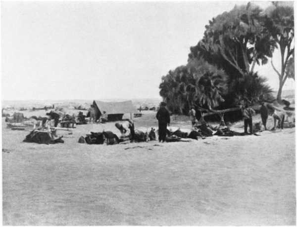
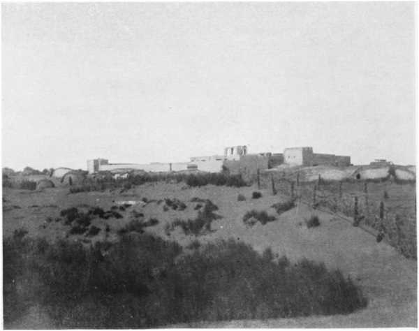
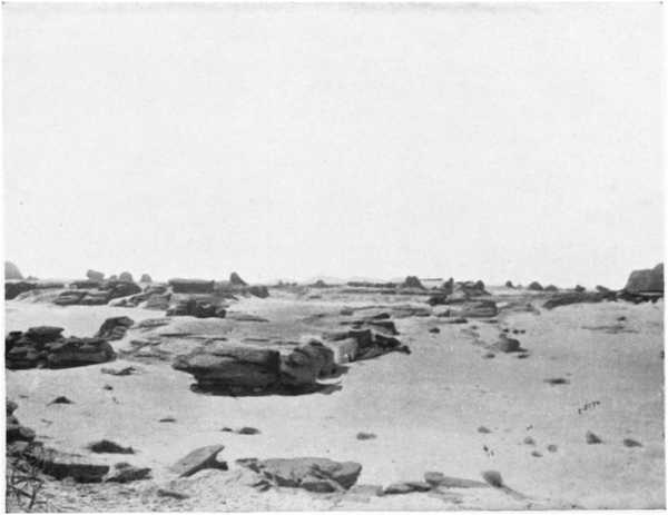
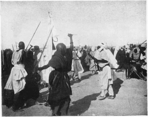
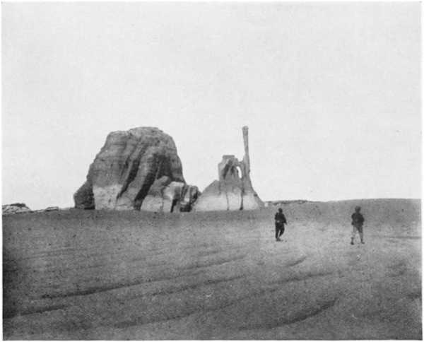
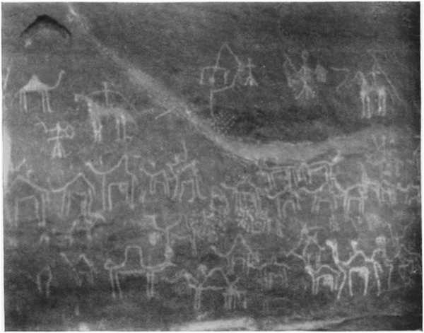
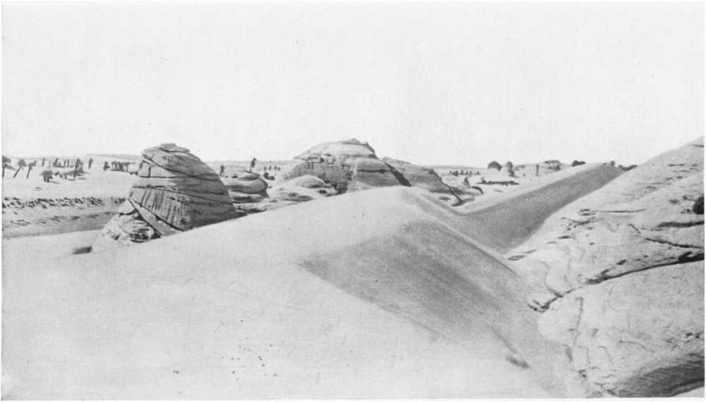
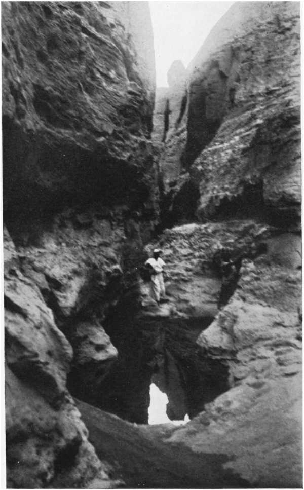
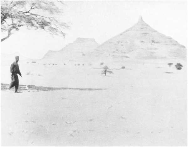
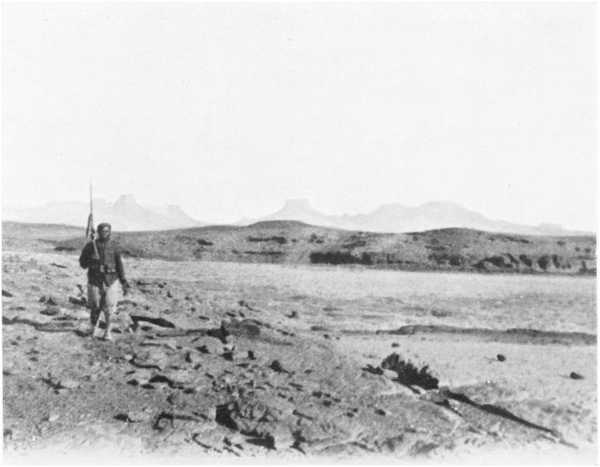
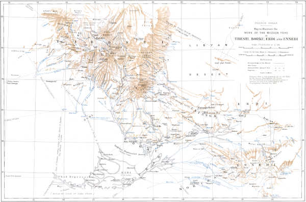
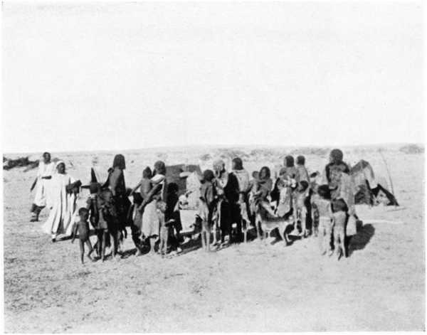
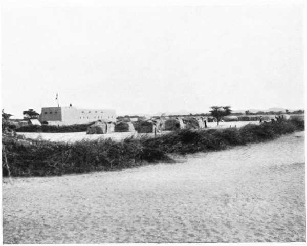
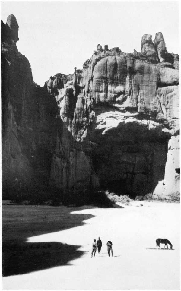
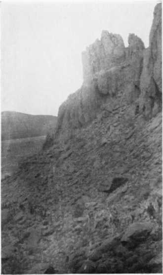
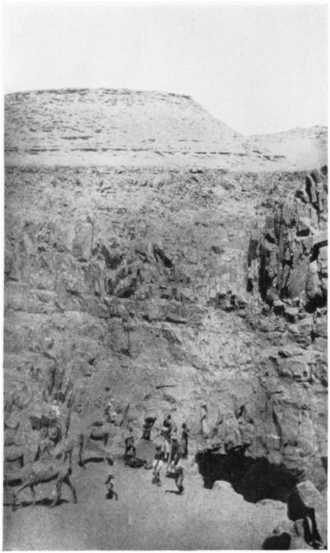
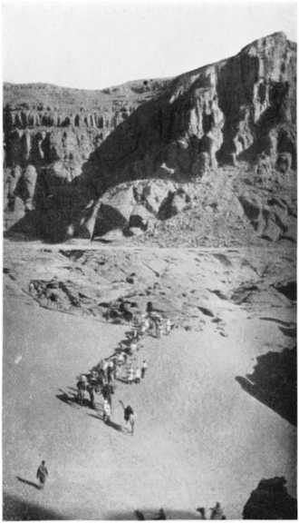
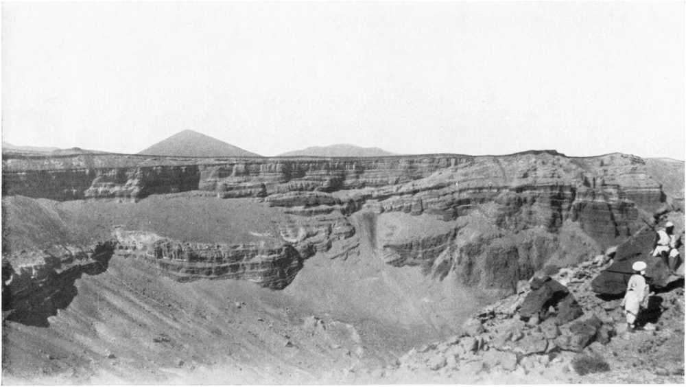
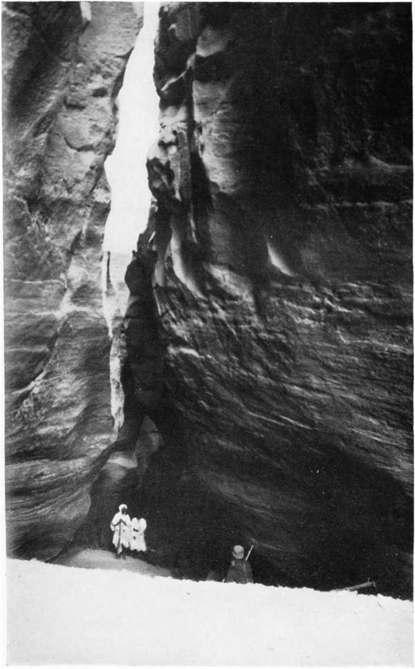
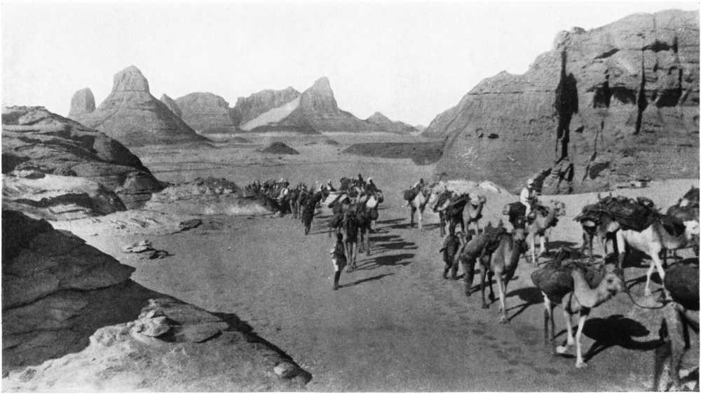
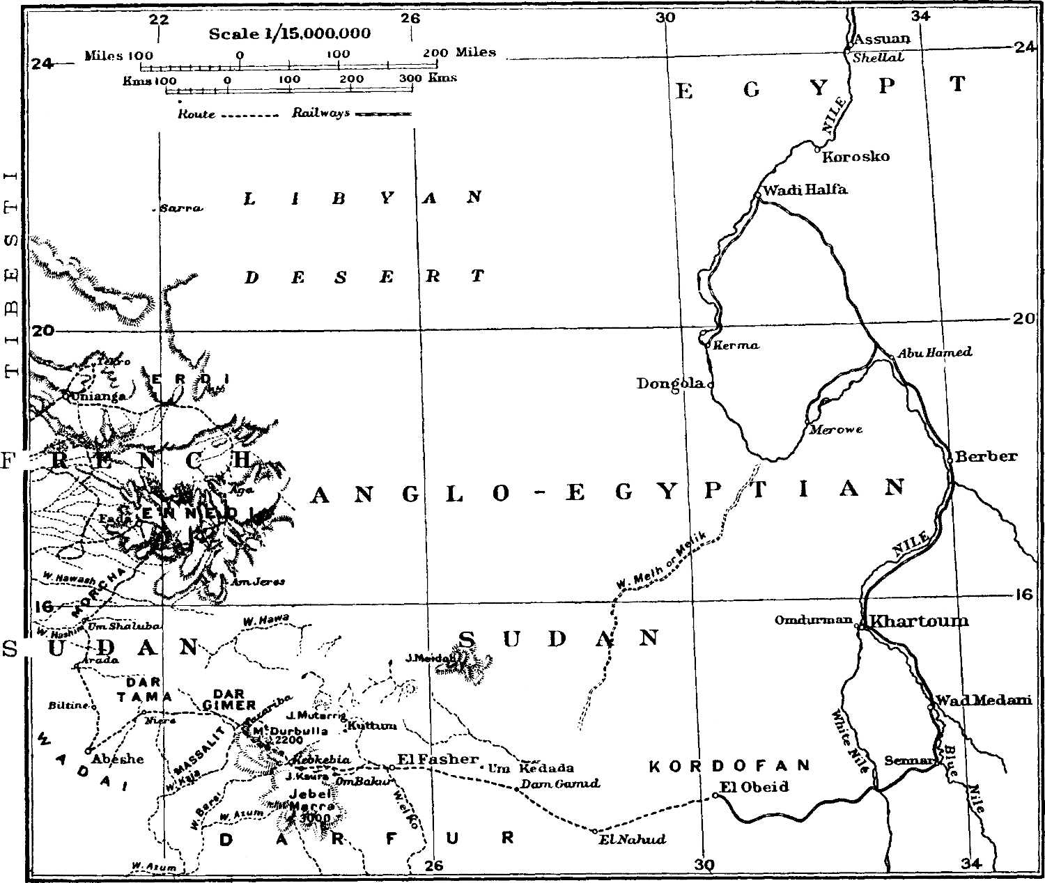